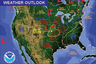
Rainy and Cool Start to the Week

A surface cold front is dropping across the plains of Colorado Sunday morning to mark the continuation of below-normal temperatures and welcome – though occasionally excessive - rain.
Eastern Colorado
Over the coming days, counties across east central and northeast Colorado can expect showers and thunderstorms starting Sunday afternoon. Over a 48-hour period, over 1.5 inches of rain is predicted across the area. Portions of Lincoln and Elbert counties may see close to two inches in areas already saturated from recent storms that produced flash flooding Friday.
Heavy rain, with a few severe storms, will be widespread and continue into the Monday morning hours.
Sunday’s high temperatures will generally be in the upper 70s, though Eads, La Junta, Lamar and Springfield may see low to mid-80s.
Cool and wet conditions continue Monday and Tuesday. Showers and storms will start across the higher elevations before spreading to the plains later in the day. Temperatures will be below seasonal norms, with lows to mid-70s for most of the area, and mid- to upper 60s from Limon to Fort Morgan.
By Wednesday, look for some warming to the low 80s for the southeast, and continuing mid- to upper 70s for the northeast. Temperatures will generally remain below normal through the end of the week.
West Slope
Though a bit drier, moisture remains plentiful across western Colorado. Scattered to numerous showers and thunderstorms will develop over the southwest part of the state Sunday afternoon, while northwest Colorado north of Interstate 70 remains drier. Small hail and locally heavy rain can be expected with the stronger storms. Monday’s pattern will be similar.
Conditions will remain unsettled throughout the week, though chances for thunderstorms remains questionable.
For temperatures, look for upper 70s to low 80s in most areas, with Grand Junction remaining the hot spot with mid- to upper 80s and a potential to reach 90 by the middle of the week.
Weather updates are available throughout the day at http://KiowaCountyPress.net/weather
Forecast - August 6 - 9 | ||||||||
Sunday | Monday | Tuesday | Wednesday | |||||
City | High | Low | High | Low | High | Low | High | Low |
Eads | 81 | 60 | 72 | 58 | 74 | 48 | 80 | 59 |
Springfield | 80 | 60 | 72 | 57 | 76 | 59 | 81 | 60 |
Trinidad | 77 | 57 | 72 | 55 | 76 | 55 | 80 | 57 |
Limon | 78 | 55 | 65 | 63 | 70 | 54 | 75 | 54 |
Sterling | 77 | 57 | 70 | 53 | 72 | 54 | 77 | 55 |
Fort Morgan | 79 | 56 | 68 | 54 | 75 | 54 | 79 | 56 |
Craig | 82 | 55 | 75 | 51 | 76 | 51 | 78 | 51 |
Grand Junction | 87 | 64 | 84 | 61 | 86 | 61 | 89 | 62 |
Montrose | 80 | 57 | 80 | 55 | 82 | 55 | 83 | 56 |
Cortez | 77 | 57 | 80 | 55 | 82 | 55 | 83 | 56 |