El Niño nears record strength: what it could mean for Colorado and the nation

The El Niño building in the Pacific Ocean grew stronger again in October, and federal forecasters now say it has a better-than-even chance of becoming the strongest since record keeping began in 1950. If it does, its effects could be felt across the United States this winter, from wetter weather along the southern tier of states to a milder winter across the north.
The Climate Prediction Center said Thursday that ocean temperatures in the east-central Pacific, the region forecasters watch most closely, ran 2.5 degrees Celsius, about 4.5 degrees Fahrenheit, above normal in its latest weekly reading. Off the coast of South America, they ran 4.4 degrees Celsius above normal.
The center put the chance of a strong or very strong El Niño lasting through January to March 2027 at greater than 79 percent, and gave about a 60 percent chance that the event will top every El Niño since 1950. It expects El Niño to keep strengthening and begin to weaken early in 2027.
The center measures El Niño with an index averaged over three months. The record on that index is 2.40, set in the winter of 1982-83. The latest value, for August through October, is 1.97. In October, the center said the models it relies on pointed to a peak this winter of roughly 3.0 to 3.5 degrees Celsius above normal on a similar measure.
What El Niño does
Most years, trade winds push warm surface water across the Pacific toward Asia. During El Niño those winds weaken, and the warm water spreads east. The shift changes where storms form and how the jet stream, the river of air that steers storms, flows over North America. A strong El Niño tends to strengthen the southern branch of the jet stream, steering more storms across the southern half of the United States.
The center cautioned that even an event this strong is no guarantee, writing only that "the chances of experiencing impacts consistent with El Niño are higher."
Across the country
The center's seasonal outlook, issued October 15, was built largely around El Niño. For November through January, it favors above-normal precipitation for much of California and the Southwest, the central and southern Plains, the Southeast and the East Coast. The best odds for a wet winter are in the Southeast and Florida.
Drier-than-normal weather is favored for the northern Rockies, parts of the Great Lakes and much of interior Alaska.
Much of the northern half of the country is expected to be warmer than normal, with the highest odds from the Pacific Northwest across the northern Plains to the Great Lakes and the interior Northeast. Temperatures in the Southwest and parts of the southern Plains are a toss-up, and the center said parts of the Southwest could turn cooler than normal by late winter and spring.
El Niño has already left a mark on this year's hurricane seasons. The center noted a far busier than normal season in the central and eastern Pacific and a far quieter one in the Atlantic, a pattern typical of El Niño.
What it has meant for Colorado
Colorado sits near the line between the wetter South and the drier North, and its record is mixed. The Kiowa County Press compared precipitation from November through April with the Climate Prediction Center's El Niño index for every winter since 1950-51, using federal climate records for each of the state's five climate regions.
There have been seven strong El Niño winters in that time. Statewide, six of the seven were wetter than a typical winter, but only modestly. On average they brought 8 percent more precipitation than all winters.
The benefit has been concentrated on the eastern plains. Strong El Niño winters averaged 35 percent more precipitation than usual on the eastern plains that drain toward Kansas, and 21 percent more in the Arkansas River basin, which includes the Arkansas Valley and the southeast plains. The South Platte basin, which includes Denver and the northern Front Range, averaged 13 percent more, and the San Luis Valley 9 percent more.
On the Western Slope, which feeds the Colorado River, strong El Niño winters have averaged no more precipitation than any other winter.
That matches a September analysis by the Colorado Climate Center at Colorado State University, which found that El Niño years tend to be wetter in Colorado, especially in fall and spring. It found the Front Range and eastern plains are more prone to large spring snowstorms during El Niño, but that the link to peak mountain snowpack is weak, with only the San Juan and Rio Grande basins showing a loose tendency toward more snow.
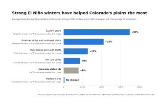
Average November-April precipitation in the seven strong El Niño winters since 1950, compared with all winters, by Colorado climate region. Kiowa County Press chart; data from NOAA's National Centers for Environmental Information and Climate Prediction Center
A wet start
Colorado did not wait for winter. Statewide precipitation in September and October totaled 5.81 inches, according to preliminary figures from the National Centers for Environmental Information. That is the second-highest for those months since 1895, behind 6.78 inches in 1941, and about twice the 1991-2020 average of 2.91 inches.
Much of it fell in southern Colorado, where a string of storms brought record flooding around Pagosa Springs and Durango in late October and again in early November. The Colorado Climate Center said October was the fourth-wettest and fourth-warmest on record statewide.
The rain followed one of the driest winters on record. Statewide precipitation from November 2025 through April 2026 was 4.73 inches, the fourth-lowest since records began.
The wet fall has cut the state's drought sharply. The share of Colorado in drought on the U.S. Drought Monitor fell from 89 percent at the start of September to 38 percent on November 10. Most of the southeastern plains, including Kiowa County, is now free of drought. Extreme drought or worse hangs on along the northern Front Range and in parts of the central and northern mountains.
The winter outlook for Colorado
For December through February, the center's outlook gives the southeastern and east-central plains a 40 to 50 percent chance of above-normal precipitation, the strongest wet lean in the state. The odds tilt the same way, though less strongly, across much of the rest of Colorado, while the northwest corner has equal chances of a wet, dry or normal winter. The wet lean spreads and strengthens into early spring. Winter temperatures are a toss-up across the state.
The center will update its seasonal outlooks November 19. Its next El Niño discussion is scheduled for December 10.