Lamar climbs to 92 Monday before windy Tuesday cools Prowers County

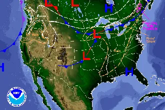
Lamar will see the hottest day of the week on Memorial Day with a high near 92, followed by a windy Tuesday as a low pressure system approaches the Four Corners and pulls strong southerly winds across the southeast plains, the National Weather Service in Pueblo said. Thunderstorm chances run 20 to 30 percent each afternoon and evening from Monday through Wednesday.
Monday is sunny in Lamar with a south-southeast wind 5 to 10 mph increasing to 15 to 20 mph in the afternoon and gusts to 30 mph. A 20 percent chance of showers and thunderstorms develops after 4 p.m. Overnight, the low drops to around 51 with a 30 percent chance of brief evening storms and breezy south-southeast winds 20 to 25 mph.
“Monday will be our hottest day this week, with highs in the 80s to low-90s over the plains,” forecaster Tony Garberoglio wrote in Sunday’s Area Forecast Discussion from the Pueblo office. He added that high-based showers will move off the southeast mountains during the afternoon and evening, with “little to no precip ... expected to hit the ground, mainly just resulting in windy virga.”
Windy Tuesday with storm potential
Tuesday is the windier day of the period. The Pueblo office is forecasting sustained south-southeast winds of 20 to 30 mph at Lamar with gusts approaching 45 mph, partly sunny skies and a 30 percent chance of afternoon and evening showers and thunderstorms. Highs ease to around 85.
No Red Flag Warning was in effect for Prowers County (fire-weather zone 236) as of Sunday afternoon. The most recent Pueblo fire-weather product was a May 18 cancellation for the far southern plains. Still, the combination of dry surface conditions, low humidity and gusts approaching 45 mph warrants caution with any open flame outdoors Monday through Wednesday.
Lamar, Colo. — Five-day forecast (May 25–29)
Source: National Weather Service, Pueblo — Issued Sunday, May 24, 2026
| Period | Sky Conditions | High/Low | Wind |
|---|---|---|---|
| Monday | Sunny; 20% T-storms late PM | 92 | SSE 15–20 mph, gusts 30 mph |
| Monday night | 30% T-storms; mostly cloudy | 51 | SSE 20–25 mph, gusts 35 mph |
| Tuesday | Partly sunny; 30% T-storms PM | 85 | SSE 20–30 mph, gusts to 45 mph |
| Tuesday night | Mostly cloudy; 30% T-storms | 48 | SSE 20–25 mph, gusts 40 mph |
| Wednesday | Partly sunny; 30% T-storms PM | 82 | SSE 15–20 mph, gusts 35 mph |
| Wednesday night | 30% T-storms; partly cloudy | 48 | SE 10–15 mph |
| Thursday | Mostly sunny; 10% T-storms PM | 86 | SE 10–15 mph |
| Thursday night | Mostly clear | 50 | SE 15–20 mph |
| Friday | Sunny | 92 | S 15–20 mph, gusts 30 mph |
| Friday night | Partly cloudy | 50 | S 15–20 mph, gusts 35 mph |
(Kiowa County Press)
Tuesday and Wednesday
Wednesday brings a high near 82 with a 30 percent chance of afternoon and evening thunderstorms. Breezy south-southeast winds 15 to 20 mph gust to 35 mph. New precipitation of less than a tenth of an inch is forecast, though locally higher amounts are possible in any thunderstorm. Overnight, the low falls to around 48 with continued storm chances mainly before midnight.
Extended outlook: Thursday and Friday
Drier air filters back into the area Thursday under mostly sunny skies with a high near 86. Friday warms back to around 92 under sunshine, with a south wind 15 to 20 mph gusting to 30 mph. The Climate Prediction Center’s 6-to-10 day outlook, valid May 30 through June 3, and its 8-to-14 day outlook, valid June 1 through 7, are consistent with the Pueblo office’s note that beyond midweek the pattern remains “warm and dry with some mixed in daily showers/storms possible.”
Residents should be prepared for the possibility of brief, locally strong wind gusts and lightning with any afternoon storm. The Lamar Municipal Airport’s hourly observations and the latest forecast are available at weather.gov/pub.