A magnitude 3.4 earthquake near Stonewall Gap is the Raton Basin's second in eight days

© iStock
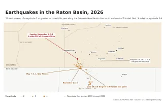
An earthquake of magnitude 3.4 struck Las Animas County at 3:34 a.m. Sunday, November 8, about 5 miles south-southeast of Stonewall Gap and 9 miles southwest of Weston, according to the U.S. Geological Survey. The epicenter was in the hills of the upper Purgatoire River country, about 6 miles north of the New Mexico line. No damage or injuries were reported.
©
Two people had told the agency's "Did You Feel It?" survey by Sunday morning that they felt it, one in Weston, who rated the shaking weak, and one in Trinidad, 28 miles to the east. Earthquakes of this size are usually felt within a few dozen miles as a short jolt or a rumble. Trinidad is 28 miles from the epicenter, Walsenburg 39 and Raton, New Mexico, 33.
The Geological Survey has reviewed the event. It located the quake with readings from 22 seismic stations and puts the horizontal uncertainty at about 1.8 miles.
Second in eight days
Sunday's quake comes a week after a magnitude 3.7 on November 1, which struck about 6 miles to the south-southeast, 11 miles south-southwest of Weston, and was followed that night by a magnitude 2.6 about 6 miles south-southeast of Stonewall Gap. Sunday's epicenter is also about 5 miles north of the magnitude 3.8 of June 20, the strongest in Colorado this year. Sunday's quake is tied with an April 9 quake south-southwest of Weston as the third-strongest in the state in 2026.
By the Geological Survey's count, it was the 24th earthquake of magnitude 2.5 or greater in Colorado this year and the 13th on the Colorado side of the Raton Basin, the coal country along the state line south and west of Trinidad. Six of the basin's 13 have been magnitude 3 or greater. Within 30 miles of Sunday's epicenter, on both sides of the state line, the agency's catalog lists 27 earthquakes of magnitude 2.5 or greater in 2026 and 410 since 2000, including 192 of magnitude 3 or greater. The largest this year in that circle was a magnitude 4.1 on May 7, about a mile south of the state line in Colfax County, New Mexico.
Why the basin shakes
The basin's earthquakes are not a mystery. A Geological Survey study published in 2014 concluded that deep injection of wastewater from coalbed methane wells was responsible for most of the earthquakes in the basin since 2001, when the shaking picked up sharply. The largest, a magnitude 5.3 near Trinidad on August 23, 2011, was the largest earthquake in Colorado since 1960, tied with a 1967 quake northeast of Denver, according to the Colorado Geological Survey.
In a 2023 presentation summarized by the Geological Survey, agency seismologist Margaret Glasgow described three zones of earthquakes in the basin, each made up of short faults a mile or two long. Earthquakes in the Trinidad zone, where the 2011 quake struck, have dropped off since about 2016, she said, most likely because wastewater injection nearby was cut by about 80 percent. This year's quakes, including Sunday's, are in the hills along the state line south of Weston and Stonewall Gap, west of the Trinidad zone.
What to do
The Geological Survey asks anyone who felt the earthquake to report it on the event's page, where "Did You Feel It?" responses help map how far the shaking reached. For a larger quake, the advice from the Great ShakeOut drill is to drop, cover and hold on, stay away from windows, and if outdoors, move away from buildings and power lines. The Colorado Geological Survey rates the state's earthquake hazard as low to moderate and counts more than 700 earthquakes of magnitude 2.5 or greater since 1867.