Red Flag Warning blankets western Colorado and the mountains as extreme fire weather sets in

A Red Flag Warning covered much of western Colorado and the state's mountains Saturday as hot, dry and windy conditions set the stage for dangerous wildfire weather. The National Weather Service warned that gusty winds and extremely low humidity could let any fire that starts spread rapidly, with the greatest danger across the lower western valleys and the Four Corners. The warning stretched from the Grand Valley and the San Juans to the central mountains and the San Luis Valley, and forecasters said the dry, windy pattern would persist into next week.
The Grand Junction office called it an extreme fire weather day, with single-digit humidity and afternoon wind gusts of 45 to 55 mph expected across the western valleys. Red Flag Warnings — the highest level of fire weather alert, meaning conditions are ripe for rapid fire growth — were in effect from 10 a.m. to midnight across roughly 25 mountain and western-valley zones, issued by the Grand Junction, Boulder and Pueblo forecast offices.
Extreme drought conditions across Colorado further increase the fire risk.
Where the warning is in effect
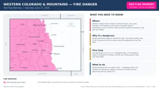
©
Source: NWS Grand Junction, Boulder and Pueblo Red Flag Warnings via the Iowa Environmental Mesonet — in effect the afternoon and evening of June 27, 2026. Times are Mountain.
(Kiowa County Press)
The Red Flag Warning blanketed the western half of Colorado and the high country: the Grand Valley, the Gunnison Basin, the San Juan Mountains, the Paradox and North Fork valleys and the Four Corners area in the west and southwest; the Routt and Park areas and the Grand and Summit county mountains to the north and center; and the San Luis Valley, the Sangre de Cristo range and the Pikes Peak and Rampart Range region to the south. Colorado's eastern plains, including the communities the Press covers most closely, were not included in the warning.
Why the danger is so high
Forecasters at the National Weather Service in Grand Junction described an extreme fire weather setup driven by a low-pressure system dropping in from the Pacific Northwest, which is tightening the pressure gradient and driving strong afternoon winds. Relative humidity is expected to fall into the single digits across much of the west, with gusts of 45 to 55 mph and locally higher. Any fires that develop over the next 48 hours, the office said, will have the potential to spread rapidly. While recent rain has dampened the threat somewhat in the higher elevations of the San Juans and central mountains, the lower elevations around the Four Corners and the Grand Valley remain tinder-dry.
The office also flagged a less obvious concern: holdover lightning. Lightning strikes from recent days can ignite organic material deep underground, where it can smolder undetected for days before erupting into a visible wildfire when the weather turns hot, dry and windy — exactly what is expected this weekend.
How long it lasts
Today's Red Flag Warning runs from 10 a.m. to midnight. The Grand Junction office has already issued additional Red Flag Warnings for parts of the west on Sunday, and the Pueblo and Boulder offices have posted a Fire Weather Watch for the central and southern mountains for Sunday. Forecasters say critical fire weather conditions are likely to continue into next week, with the strongest winds expected Sunday and Monday as the pressure gradient peaks.
Preventing fires
With fuels primed to burn, the Weather Service urged residents and visitors to avoid anything that could throw a spark. That means no open burning and no fireworks, and care with equipment: keep vehicle chains from dragging on the ground, avoid parking hot vehicles over dry grass, and put off welding, grinding or mowing dry vegetation during the windiest afternoon hours. Obey all local fire restrictions and burn bans. Report any fire or smoke immediately by calling 911 — under these conditions, a small fire can grow dangerous within minutes.