Severe weather to intensify over eastern Colorado Tuesday after Monday's hail and high winds

Eastern Colorado faces its most dangerous severe weather day of the week Tuesday, with the Storm Prediction Center raising the central and eastern plains to an enhanced risk — level 3 on its five-step scale — after strong storms again swept the region Monday. Forecasters expect supercell thunderstorms capable of very large hail, damaging winds and an isolated tornado to develop in the afternoon and continue into the late evening, with the greatest concern along and east of the Interstate 25 corridor.
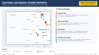
The escalation follows a busy Monday across the plains. Hail up to 4 inches across — softball size — fell near Joes in Yuma County, 3-inch stones were reported around Sterling and Cope, and a fast-moving storm cluster produced measured wind gusts as high as 113 mph near Akron, in Washington County. Three brief tornadoes also touched down, including two near Fowler in the southeast plains. As of Tuesday morning, no severe thunderstorm or tornado watches had been issued; those are typically posted a few hours before the first storms develop. Ahead of the storms, Tuesday stays warm, with highs near 85 at Cheyenne Wells, 89 at Eads and 94 at Lamar.
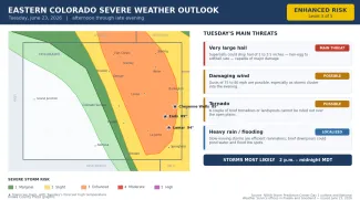
At a glance: Tuesday's severe weather risks
©
Source: NOAA Storm Prediction Center Day 1 outlook and National Weather Service offices in Pueblo and Goodland — issued the morning of June 23, 2026. Times are Mountain.
(Kiowa County Press)
What happened Monday
Monday's storms again concentrated over the northeast plains, with a second, smaller area over the southeast plains, largely sparing the counties the Press follows most closely. The standout report was 4-inch hail near Joes in Yuma County, with 3.5-inch hail near Cope in Washington County and several 3-inch reports near Sterling in Logan County. The most striking threat came from wind: the storm cluster near Akron produced a string of measured gusts from 80 to 113 mph late in the evening — the kind of straight-line wind that can flatten crops, snap power poles and damage buildings. Closer to home, brief tornadoes were reported near Fowler, between Pueblo and the Arkansas River, and large hail reached Crowley and Pueblo counties. All reports are preliminary and subject to National Weather Service review.
©
Preliminary hail, wind and tornado reports across eastern Colorado on Monday, June 22, 2026.
(Kiowa County Press)
What the Storm Prediction Center is saying
In its Tuesday outlook, the Storm Prediction Center in Norman, Okla., placed much of the central and eastern Colorado plains, including Cheyenne Wells, Eads and Lamar, in an enhanced risk for severe storms — level 3 of 5 — with a slight risk, level 2, along the immediate Kansas border and across south-central Colorado. Forecasters said upslope flow, surface dewpoints near 60 degrees and steep mid-level lapse rates would build strong instability, while about 50 knots of wind shear would favor supercells — rotating, long-lived storms — capable of all severe hazards. They warned that hailstones could reach the 2-to-3.5-inch range, that wind gusts could well exceed 75 mph, and that any storm able to tap low-level spin near the higher terrain could produce a landspout or hybrid tornado.
Timing and where the storms are most likely
The National Weather Service office in Pueblo, which covers the southeast plains including Kiowa, Prowers, Bent, Otero, Crowley and Baca counties, expects a warm capping layer to limit daytime storms before a strong westward surge of moisture collides with the higher terrain in the evening. Forecasters there said the evening and early overnight hours bring the greatest concern, with a couple of intense supercells possible along the I-25 corridor capable of 2-to-3-inch hail, possibly larger, and strong to severe storms lingering east of the corridor overnight, carrying hail around 1 to 1.5 inches and damaging winds near 60 mph.
The Goodland, Kan., office, which covers Cheyenne, Kit Carson and Yuma counties, said severe storms capable of up to 3-inch hail, 80 mph wind gusts and a tornado or two were possible during the afternoon and evening, with eastern Colorado the favored area. Forecasters there cautioned that slow-moving storms could also produce localized flooding over ground already soaked by recent rain.
Potential impacts
Very large hail is again Tuesday's standout threat. Stones of two inches or more — between hen-egg and softball size — can fall in a narrow path beneath the strongest storms, denting vehicles, breaking windows, damaging roofs and siding, and destroying gardens and crops. Wind gusts of 75 mph or higher can snap tree limbs, down power lines, knock out electricity and kick up sudden blowing dust that drops highway visibility with little warning. The tornado threat is lower-end but real over the open plains, and any rotating storm should be watched closely. Because the strongest storms are expected to move slowly, brief but heavy downpours could pond water on low-lying roads.
Fire weather and the days ahead
West of the storm threat, a red flag warning for critical fire weather is in effect from noon to 9 p.m. Tuesday over the western mountains and valleys, where gusty winds and single-digit humidity raise the wildfire risk, and the Pueblo office has posted a fire weather watch for Wednesday. The unsettled, storm-prone pattern over the eastern plains is forecast to continue through about Friday, with strong to severe storms possible each afternoon and evening. Drier and hotter weather then looks to return this weekend, which forecasters say could bring renewed and more widespread critical fire weather to the region.
Staying safe
A severe thunderstorm or tornado watch means conditions are favorable for dangerous storms to develop over the next several hours — a signal to stay alert and know where you would take shelter. A warning means a dangerous storm is happening or imminent in your area, and you should act right away. Make sure you have a reliable way to receive warnings, such as a NOAA Weather Radio or alerts on your phone, and do not count on hearing an outdoor siren from indoors.
With very large hail and strong winds the main dangers, the safest place is indoors, away from windows and skylights. If you can hear thunder, lightning is close enough to strike, so stay inside until at least 30 minutes after the last rumble. If a tornado warning is issued, move to the lowest floor and an interior room. Drivers should slow down in heavy rain, watch for sudden gusts and blowing dust, and never enter a flooded roadway. Before storms arrive, secure or bring in loose outdoor items, move vehicles under cover where possible, and check on neighbors, livestock and pets. The latest watches, warnings and timing are available at weather.gov.