Severe weather threats continue across the U.S. Sunday
The National Weather Service warns a potent mid-May weather pattern will unleash widespread severe thunderstorms, flash flooding, and dangerous heat across much of the Lower 48 through Tuesday (May 20). A strengthening storm system currently moving east from the Intermountain West is expected to trigger heavy rainfall, large hail, damaging winds, and an enhanced risk for tornadoes in central and southern Plains states today.
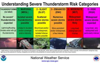
The storm, which has already dumped mountain snow across Idaho and western Montana - up to a foot in some areas - will expand its reach tonight as thunderstorms erupt from northeast Colorado through the Concho Valley of Texas. The Storm Prediction Center has issued an Enhanced Risk (level 3/5) for severe weather from central Kansas into central Oklahoma, with tornado threats possible. A Slight Risk of Excessive Rainfall (level 2/4) covers eastern Kansas, Oklahoma, and parts of Missouri and Arkansas through Monday, as intense rainfall rates could cause flash flooding in sensitive areas.

Severe weather outlook category descriptions. Courtesy NWS.
Monday will bring another wave of strong storms as a low-pressure system dominates the central U.S., with heavy rain spreading northward into South Dakota and the Lower Mississippi Valley. Locally extreme downpours are likely from North Texas to northern Missouri, raising flood risks in urban and mountainous regions. Severe thunderstorms with large hail and damaging winds will persist across much of the southern Plains and Ozarks.
By Tuesday, the storm’s focus shifts eastward into the Midwest, Tennessee Valley, and Ohio River Valley for scattered severe weather and flash flooding. Meanwhile, critical fire weather conditions - driven by dry vegetation, low humidity, and gusty winds - are forecast for southern New Mexico and West Texas today, with Red Flag Warnings in effect.
Temperature extremes will accompany the storm system: South Texas and Florida’s Gulf Coast are bracing for mid-to-upper 90s degrees (100°F+ in south-central Texas), potentially breaking records, while frost advisories remain in place across parts of the Dakotas and Minnesota after overnight lows dipped into the 30s.
Editor’s note: Portions of this article have been augmented with the assistance of Large Language Models for analysis, with human review, editing, and original material.


