Wet, chilly start gives way to sunshine and 80s by Saturday in Eads

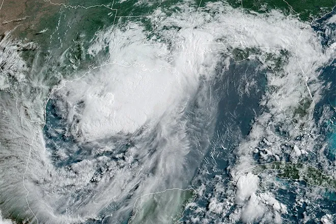
A spring storm parked over southeast Colorado is bringing rain and snow showers to Eads on Wednesday before the system slides east, opening the door to a stretch of sunshine and a steady warm-up that should push afternoon highs into the low 80s by Saturday.
Wednesday is the wettest day of the week in Eads, with rain mixed with snow showers giving way to all rain after 4 p.m. and a high near 40, the National Weather Service in Pueblo said. Winds are out of the east-northeast at 5 to 10 mph, with chances of precipitation at 100 percent. Less than an inch of new snow accumulation is possible in the area.
Forecasters in Pueblo said the storm has been pulling moisture upslope and pinning daytime temperatures roughly 30 degrees below normal. "Wintry weather will continue across our area throughout the day today and into this evening, thanks to the merging of some passing upper troughs," forecaster Garberoglio with the National Weather Service in Pueblo wrote in Wednesday's Area Forecast Discussion.
Hard freeze expected overnight Wednesday
A Freeze Warning is in effect for Kiowa County from midnight Wednesday until 8 a.m. Thursday, with overnight lows in Eads forecast to drop to around 25 degrees. Tender vegetation, newly planted gardens and exposed pipes are at risk during the warning period. The Pueblo office issued the warning as part of a broader plains advisory covering zones COZ083 through COZ089 and COZ093 through COZ099.
Skies clear through the night as the system tracks east, setting up colder air across the plains. Forecasters wrote that lows will sink "into the 20s across the plains, where a Freeze Warning will be in effect."
Eads, Colo. — Five-day forecast (May 6 – May 10)
Source: National Weather Service, Pueblo — Issued May 6, 2026
Period | Sky Conditions | High/Low | Wind |
|---|---|---|---|
| Wed., May 6 | Rain & snow showers, becoming rain after 4 p.m. | High 40 | ENE 5–10 mph |
| Wed. night | Chance showers early; clearing | Low 25 | NNE 5–10, becoming WSW |
| Thu., May 7 | Partly sunny then sunny; breezy | High 70 | WSW 10–20 mph |
| Thu. night | Mostly clear | Low 37 | SW 5–10, NW after midnight |
| Fri., May 8 | Sunny; breezy | High 73 | NW 10–20, NE in afternoon |
| Fri. night | Mostly clear | Low 40 | ENE 5–10, S after midnight |
| Sat., May 9 | Sunny; breezy | High 81 | S 10–20, N in afternoon |
| Sat. night | Mostly cloudy; slight chance t-storms | Low 41 | N 10–15 mph |
| Sun., May 10 | 20% chance showers AM; mostly sunny | High 70 | N around 10 mph |
| Sun. night | Mostly clear | Low 41 | ESE around 10 mph |
(Kiowa County Press)
Sunshine and warming Thursday and Friday
Thursday turns partly sunny early before clearing to full sunshine, with a high near 70 and a breezy west-southwest wind of 10 to 20 mph. Overnight lows ease to about 37 under mostly clear skies.
Friday continues the warm-up. Skies stay sunny and the high climbs to about 73, with northwest winds 10 to 20 mph in the morning shifting to northeast in the afternoon. Forecasters in Pueblo said the region is transitioning between systems, with a broad ridge building in over the western United States that will keep precipitation mostly out of the picture through the end of the workweek.
Weekend outlook: Saturday warmest, cooler Sunday
Saturday is shaping up to be the warmest day in the seven-day window, with sunshine and a high near 81 in Eads. South winds of 10 to 20 mph will shift to the north by afternoon. A weak disturbance moving across the region brings a slight chance of showers or thunderstorms Saturday night, with mostly cloudy skies and a low around 41.
Sunday cools behind a passing front, with a 20 percent chance of showers before noon and an afternoon high near 70 under mostly sunny skies. North winds will run around 10 mph. Skies clear Sunday night, with a low near 41.
Residents should plan for slick roads and reduced visibility during the heaviest precipitation Wednesday morning and take freeze precautions for plants and outdoor plumbing through Thursday morning.