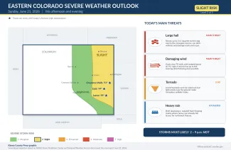
Another round of severe storms possible on eastern Colorado plains Sunday afternoon

Eastern Colorado is in line for a second straight day of strong to severe thunderstorms Sunday afternoon and evening, though the threat looks somewhat lower than Saturday's. The Storm Prediction Center has placed the eastern plains in a slight risk for severe weather — level 2 on its five-step scale — with large hail and damaging wind gusts the main concerns. Storms are expected to fire in the heat of the afternoon, generally after 2 p.m. Mountain time, and track south and east through the evening, mainly along and near the Colorado-Kansas border.
©
Forecasters say the atmosphere will be primed for a few stronger storms but note that widespread rain on Saturday may limit how explosive Sunday's activity becomes. As of Sunday morning, no tornado or severe thunderstorm watches had been issued for the Colorado plains; those are typically posted a few hours ahead of the first storms. Red flag warnings for fire weather were already in effect across parts of the mountains and high valleys to the west.
At a glance: today's severe weather risks
Source: NOAA Storm Prediction Center and National Weather Service offices in Pueblo, Goodland and Denver/Boulder — Day 1 outlook and forecast discussions issued the morning of Sunday, June 21, 2026. Times are Mountain.
| Hazard | Today's threat | What to expect |
|---|---|---|
| Large hail | Main threat | Stones up to 2 inches across — quarter- to hen-egg-size — in the strongest storms, capable of damaging vehicles, roofs, windows and crops. |
| Damaging wind | Main threat | Gusts to around 70 mph, with isolated gusts of 75 mph or higher possible, especially if storms merge into a line during the evening. Blowing dust may briefly cut visibility. |
| Tornado | Low | A brief tornado cannot be completely ruled out, but light winds near the ground make tornadoes unlikely today. |
| Heavy rain | Localized | Brief downpours are possible; isolated flash flooding could occur where heavy rain already fell, mainly across far northwest Kansas. |
(Kiowa County Press)
What the Storm Prediction Center is saying
In its morning outlook, the Storm Prediction Center in Norman, Oklahoma, kept eastern Colorado in a slight risk of severe storms, the second of five categories, with a broader marginal risk — level 1 — covering areas farther west. Forecasters explained that a disturbance in the upper atmosphere moving out of Wyoming, combined with moist air pushing up against the higher terrain, would set the stage for scattered storms during the afternoon. They expect isolated supercells — rotating, long-lived thunderstorms — to develop across eastern Colorado and into western Nebraska and Kansas, posing mainly a large to very large hail threat at first, with stones of two inches or more possible. If those storms later group together into clusters during the evening, the center said, damaging winds would become a growing concern, with isolated gusts of 75 mph or higher possible.
Timing and where the storms are most likely
The National Weather Service office in Goodland, Kansas, which covers Cheyenne, Kit Carson and Yuma counties, expects a few severe storms mainly between 2 and 9 p.m. Mountain time, capable of two-inch hail and 70 mph winds. Forecasters there said ample low-level moisture and steep changes in temperature with height would allow storms to build by mid-afternoon, but that weak winds near the ground made tornadoes unlikely. The office cautioned that ground already soaked by heavy rain on Saturday — locally three to seven inches in parts of northwest Kansas — could see isolated flash flooding if more heavy rain falls.
The Pueblo office, which covers the southeast plains including Kiowa, Prowers, Bent, Otero, Crowley and Baca counties, expects storms to form toward early evening as a weak front drops south across the plains, mainly closer to the Colorado-Kansas border. Forecasters there said the main threat would be strong straight-line winds pushing out ahead of the storms, but that any storm that stayed isolated and intensified could quickly produce large hail. The Denver/Boulder office, which covers the northeast plains including Lincoln, Washington, Logan, Sedgwick and Phillips counties, likewise pointed to the easternmost tier of counties for the greatest instability, with wind and hail the primary threats and only isolated showers expected closer to the Front Range.
Potential impacts
The most likely impacts are localized rather than widespread. Hail of an inch or larger can dent vehicles, crack windshields, damage roofs and siding, and shred gardens and crops within the narrow path of a strong storm. Wind gusts of 60 to 75 mph can snap tree limbs, blow down branches onto power lines, briefly knock out electricity, and toss unsecured outdoor furniture, trampolines and trash bins. Brief blowing dust ahead of a storm's outflow can drop visibility on highways with little warning. While the tornado threat is low, eastern Colorado's open terrain means any storm should still be watched closely, and motorists on Interstate 70 and rural highways should be ready for rapid changes in wind, rain and visibility.
Fire weather and the week ahead
West of the storm threat, red flag warnings signaling critical fire weather were in effect Sunday from late morning into the evening across parts of the Continental Divide, the Upper Arkansas Valley and the San Luis Valley, where gusty west winds and dry air raise the risk of fast-spreading wildfire. Forecasters expect that fire-weather pattern to persist over the higher terrain through much of the week. On the plains, the unsettled pattern is also expected to continue: the Pueblo, Goodland and Denver offices all anticipate near-daily afternoon and evening thunderstorms over the eastern counties into midweek, some of them again reaching severe limits, before drier and warmer weather looks to return by next weekend.
Staying safe
A severe thunderstorm or tornado watch means conditions are favorable for dangerous storms to develop over the next several hours; it is a signal to stay alert and review where you would take shelter. A warning means a dangerous storm is happening or imminent in your immediate area and you should act right away. Make sure you have a reliable way to receive warnings, such as a NOAA Weather Radio or alerts on your phone, and do not rely on hearing an outdoor siren indoors.
When a severe storm approaches, move indoors to a sturdy building, away from windows. Hail and lightning are the most common dangers: if you can hear thunder, you are close enough to be struck, so stay inside until at least 30 minutes after the last rumble. If a tornado warning is issued for your area, go to the lowest floor and an interior room such as a bathroom or closet, and put as many walls between you and the outside as possible. Mobile homes offer little protection — identify a stronger shelter nearby ahead of time.
If you are driving, slow down in heavy rain and be ready for sudden wind gusts and blowing dust, which can cause near-zero visibility on open highways; if visibility drops out, pull well off the roadway, turn off your lights and wait for conditions to improve. Never drive through a flooded road or low-water crossing — most flood deaths happen in vehicles, and it takes only a foot or two of moving water to sweep a car away. Before the storms arrive, secure or bring in loose outdoor items, move vehicles under cover if you can, and check on neighbors, livestock and pets. The latest watches, warnings and timing are available at weather.gov.