Colorado drought conditions show little improvement
According to the latest data from the United States Drought Monitor, Colorado's drought conditions remain a concern, with minimal improvement over the past week.
Compared to last week, the changes in drought conditions are relatively small. Approximately 62 percent of the state is experiencing some level of drought, a slight decrease from 65 percent last week. Twenty-seven percent is classified as severe or worse, down from 30 percent. The moderate drought category affects around 23 percent of the state, which is an increase from last week's 20 percent. The area considered abnormally dry has decreased from 15 percent to 12 percent.
©
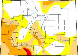
The western and southern parts of the state are bearing the brunt of drought conditions, with exceptional drought persisting in areas such as Montezuma and Dolores counties. In contrast, the northeastern counties, including Weld and Morgan, are experiencing less severe conditions, with only 10 percent of the area classified as abnormally dry.
In southeast Colorado, moderate drought has been impacting eastern Baca and Prowers counties, and the far southeast corner of Kiowa County. The remainder of Baca and Prowers have been abnormally dry. With the most recent update, moderate drought emerged for southwest Kiowa County, northern Bent County, northeast Otero County, and much of Crowley County. Cheyenne County is largely drought-free, with some abnormally dry conditions in the far southwest corner of the county.
Extreme drought continues a slow expansion in southern Colorado, impacting portions of Archuleta, Conejos, Rio Grande, and Mineral counties.
The Drought Monitor's classification system categorizes drought conditions on a scale of D0 (no drought) to D4 (exceptional drought). Currently, no region of the state is completely drought-free, with even the least affected areas experiencing some level of dryness.
While some areas have seen slight improvements in recent weeks, the overall trend remains concerning. While northern mountain snowpack has been near normal, the southern basins are well below average. Peak snow accumulation tends to occur by early April, leaving little opportunity for storms on southern mountain ranges to make up for the shortfall.
| Week | Date | None | D0 | D1 | D2 | D3 | D4 |
| Current | 4/8/25 | 48 | 20 | 20 | 11 | 1 | 0 |
| Last Week to Current | 4/1/25 | 45 | 24 | 19 | 12 | 1 | 0 |
| 3 Months Ago to Current | 1/7/25 | 71 | 18 | 7 | 3 | 1 | 0 |
| Start of Calendar Year to Current | 12/31/24 | 75 | 15 | 6 | 3 | 1 | 0 |
| Start of Water Year to Current | 10/1/24 | 48 | 27 | 20 | 5 | 0 | 0 |
| One Year Ago to Current | 4/9/24 | 65 | 32 | 3 | 0 | 0 | 0 |
Editor’s note: Portions of this article have been augmented with the assistance of artificial intelligence for analysis, with human review, editing, and original material.


