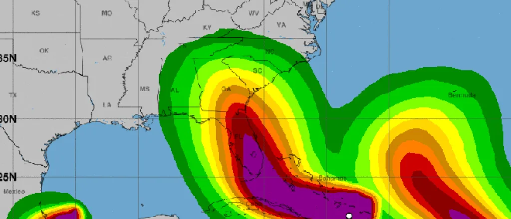
Hurricane Irma Continues Track Toward Florida
Hurricane Irma is remaining on a projected course that will take it to the Florida Keys as a major hurricane by early Sunday.
The storm, currently classified as category 4 on the Saffir-Simpson scale, is north of Cuba. The path, which may be subject to significant revisions over the coming days, takes Irma northwest along the Cuban coast before turning to a more northerly course that will pass over the Keys Sunday and then across the central Florida peninsula as a somewhat weakened hurricane through Monday.
Irma is expected to continue weakening to tropical storm strength over Georgia Tuesday morning, and continue as a tropical depression over central Tennessee Wednesday. Tennessee was also impacted by the remnants of Hurricane Harvey last week.
While the storm’s strength will fluctuate over the coming days, it is still expected to initially reach Florida as an extremely dangerous category 4 hurricane.
Florida officials have been urging residents to heed evacuation orders for days. Governor Rick Scott has been leading the call for early evacuations with frequent media appearances and extensive social media messaging. Schools across the state have been closed from Friday through Monday at the Governor’s order to encourage people to take their families to safety. Colleges and universities are included in the closure order.
The hurricane currently has sustained winds of 150 miles per hour as it moves between the central Bahamas and the northern coast of Cuba today. Earlier in the week, sustained winds were at 185 mph as Irma impacted the U.S. Virgin Islands and Puerto Rico.
Storm surge watches and warnings have been issued for southern Florida, including the Keys. Surge warnings indicate the danger of life-threatening inundation from rising water moving in from the coast over the next 36 hours.
Rain will be a major issue as Irma makes landfall on the continental U.S. The Upper Florida Keys can expect 10 to 15 inches, while eastern Florida into Georgia eight to 12 inches, with some areas receiving as much as 16 inches of rain.
Two additional hurricanes are impacting the region.
Hurricane Jose is currently a category 3 major hurricane with sustained winds of 125 mph as it approaches Atlantic island hit by Hurricane Irma earlier this week.
Jose is expected to weaken as it passes northeast of Puerto Rico Sunday morning. The current projected path keeps the storm well east of the U.S. mainland.
Hurricane Katia is in the southwest portion of the Gulf of Mexico on a track that has it making landfall over Mexico early Saturday. It will rapidly weaken to a tropical storm later in the day.
Thursday night, a magnitude 8.1 earthquake and series of aftershock struck an area south of where Katia is expected to make landfall.


