
A magnitude 2.8 earthquake shook the hills south of Meeker on Sunday

© iStock - allanswart
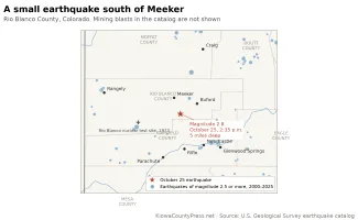
A small earthquake struck Rio Blanco County at 2:35 p.m. Sunday, October 25, about 11 miles south-southeast of Meeker, according to the U.S. Geological Survey. The agency's reviewed magnitude is 2.8, at a depth of about 5 miles. No damage or injuries were reported, and as of Sunday evening no one had filed a "Did You Feel It?" report with the agency.
The epicenter was in the hills between Meeker and Rifle, about 24 miles north of Rifle and 26 miles northwest of New Castle. Earthquakes of this size are usually felt only near the epicenter, if at all, as a brief jolt or a sound like a passing truck. The Geological Survey located the event with readings from 38 seismic stations and puts the horizontal uncertainty at about a mile and a third.
A quiet corner
This part of northwest Colorado does not shake often. The Geological Survey's catalog lists only three natural earthquakes of magnitude 2 or greater within 15 miles of Sunday's epicenter since 2000: a magnitude 3.1 east of Meeker in October 2005, a magnitude 2.5 northwest of New Castle a year ago this week, and Sunday's. Widen the circle to 30 miles and the catalog holds 18 natural earthquakes of magnitude 2.5 or more in that span, the largest a magnitude 4.3 southwest of Craig in January 2002 and a magnitude 4.1 northwest of Parachute in August 2018.
©
The same circle holds 159 events the catalog labels as explosions. Those are blasts, clustered northeast of Meeker and southwest of Craig where the region's coal mines are, and the Geological Survey marks them separately so they are not mistaken for earthquakes.
Statewide, Sunday's quake was the 21st earthquake of magnitude 2.5 or greater in Colorado this year, by the Geological Survey's count. Most of the others were in the Raton Basin south of Walsenburg and Trinidad, where a cluster of small quakes has continued for years. The largest of 2026 was a magnitude 3.8 southeast of Stonewall Gap in Las Animas County on June 20.
The ground beneath it
The epicenter lies in the Piceance Basin, the deep bowl of sedimentary rock between the White River and the Colorado River that holds large natural gas and oil shale deposits. The Colorado Geological Survey counts more than 90 potentially active faults in the state and more than 700 recorded earthquakes of magnitude 2.5 or greater since 1867, and rates the state's earthquake hazard as low to moderate. "It is not possible to predict when or where the next large earthquake might occur in Colorado," the state survey says.
Colorado's largest known earthquake, on November 7, 1882, shook much of the state, and an early study placed it in the Piceance Basin. The state survey now puts it in the northern Front Range, with a magnitude near 6.6, and estimates a repeat would cost 22.7 billion dollars.
The basin's most famous shaking was deliberate. On May 17, 1973, the Atomic Energy Commission set off three nuclear devices in a single well at depths of 5,840 to 6,690 feet at the Rio Blanco site, about 30 miles west of Sunday's epicenter, to try to free natural gas from tight sandstone, according to the Department of Energy's Office of Legacy Management, which still monitors wells there. It was the last of three such tests, after Gasbuggy in New Mexico and Rulison near Rifle, and none of them led to commercial production.
What to do if the ground moves
The Geological Survey asks anyone who felt Sunday's earthquake to say so on the event's page, where "Did You Feel It?" reports help map how far the shaking reached. For a larger quake, the advice from the Great ShakeOut earthquake drill is to drop, cover and hold on, stay away from windows, and if outdoors, move away from buildings and power lines. Colorado takes part in the drill each October.