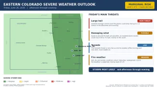
Marginal storm risk Friday on the eastern Colorado plains as a hot, dry weekend builds

The stretch of active, sometimes severe weather across eastern Colorado is winding down. Forecasters expect only isolated strong to severe thunderstorms on the plains Friday afternoon and evening, and the NOAA Storm Prediction Center has the entire eastern plains — including Eads, Cheyenne Wells and Lamar — in just a marginal risk for severe storms, level 1 of 5, the lowest category. Large hail and gusty winds are the main concerns, but the bigger story is the hot, dry and windy weekend ahead, when critical fire weather conditions are expected to return.
After a dry start, scattered storms are expected to build over the higher terrain by early afternoon and drift east across the plains by mid to late afternoon, weakening as they move into drier air. The strongest storms could produce hail up to 1.5 inches and wind gusts to 65 mph. This article was prepared early Friday morning, and conditions may change as the day unfolds.
At a glance: Friday's severe weather risks
©
Source: NOAA Storm Prediction Center Day 1 outlook and National Weather Service offices in Pueblo and Goodland — issued the morning of June 26, 2026. Times are Mountain.
(Kiowa County Press)
What the Storm Prediction Center is saying
In its Friday morning outlook, the Storm Prediction Center in Norman, Okla., placed all of eastern Colorado in a marginal risk for severe storms, level 1 of 5 — a step down from the slight and enhanced risks of recent days. The higher slight-risk area sat east of the state, over the central Plains. Forecasters said any severe storms in Colorado would be isolated, with hail and wind the only real threats and the activity weakening through the evening.
Timing and where the storms are most likely
The National Weather Service office in Pueblo, which covers the southeast plains including Kiowa, Prowers, Bent, Otero, Crowley and Baca counties, expects thunderstorms to form over the higher terrain by early afternoon and spread onto the plains by mid to late afternoon. As storms move east into richer low-level moisture, an isolated storm or two could turn strong to severe, with large hail to 1.5 inches and winds to 65 mph possible. Most of the day, though, is expected to be dry and breezy, with gusts to around 30 mph.
The Goodland, Kan., office, which covers Cheyenne, Kit Carson and Yuma counties, said storms forming along the Front Range should push into eastern Colorado around 5 to 7 p.m. but weaken as they move away from their best support, likely producing just one marginally severe storm with the rest of the area seeing little. Forecasters there noted a low chance that storms could cluster and bring damaging winds of 60 to 75 mph, mainly across southern areas. A flood watch tied to recent heavy rain was set to expire at midnight Friday.
What happened Thursday
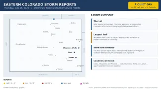
©
Thursday marked a sharp break from the active pattern of the preceding days. Across all of eastern Colorado, the National Weather Service logged just a single severe report — a 60 mph wind gust near Rockport in northern Weld County, close to the Wyoming line. No severe hail and no tornadoes were reported anywhere on the plains.
Preliminary hail, wind and tornado reports across eastern Colorado on Thursday, June 25, 2026.
(Kiowa County Press)
For the counties the Press follows most closely — Kiowa, Cheyenne and Prowers — it was another quiet day, continuing a stretch in which the heaviest weather has stayed well to the north. All reports are preliminary and subject to National Weather Service review.
Potential impacts
With only a marginal risk, widespread severe weather is not expected Friday. The main hazards from any stronger storm would be hail up to about 1.5 inches, which can dent vehicles and bruise crops, and wind gusts to 65 mph capable of knocking down branches and kicking up blowing dust. Brief heavy downpours are possible under the strongest cells, but most areas will see little or no rain. The tornado threat is very low.
Fire weather and the days ahead
The bigger weather story is the weekend. The Pueblo office has issued a fire weather watch for Saturday across the mountains and valleys to the west and warns that widespread critical fire weather conditions are likely Saturday into early next week, especially west of the Interstate 25 corridor, as hot, dry and windy weather settles in. Highs will climb into the 90s and around 100 on the plains, with afternoon winds gusting to 35 mph or more and humidity dropping into the teens. Recent rain has greened up grasses and may temper the fire danger somewhat on the far eastern plains, but residents should still use caution with anything that could spark a fire.
Staying safe
A severe thunderstorm or tornado watch means conditions are favorable for dangerous storms to develop over the next several hours — a signal to stay alert and know where you would take shelter. A warning means a dangerous storm is happening or imminent in your area, and you should act right away. Make sure you have a reliable way to receive warnings, such as a NOAA Weather Radio or alerts on your phone.
With hail and gusty winds the main storm dangers Friday, the safest place during any storm is indoors, away from windows. If you can hear thunder, lightning is close enough to strike, so stay inside until at least 30 minutes after the last rumble. As the dry, windy weekend arrives, avoid activities that could start a grass fire — dragging chains, parking hot vehicles over dry grass or burning trash — and report any wildfire immediately. The latest watches, warnings and timing are available at weather.gov.