Saturday's storms bring up to tennis-ball hail to northeast Colorado; rainfall stays light

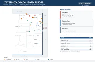
Severe thunderstorms raked the northeast Colorado plains on Saturday afternoon and evening, dropping large hail and kicking up strong winds, though the heaviest rain and the day's tornadoes stayed east of the state line. The largest hail reported in Colorado was 2.50 inches across — tennis-ball size — near Logan Corners in Logan County, according to preliminary National Weather Service reports. The strongest measured wind gust was 66 mph in Yuma County. No tornadoes were reported in Colorado.
The storms developed under a pair of tornado watches and a severe thunderstorm watch that covered most of eastern Colorado into the evening. The most intense weather, however, set up just across the border: brief tornadoes touched down in Rawlins and Sheridan counties in northwest Kansas, where wind gusts reached 89 to 100 mph and three to seven inches of rain produced flooding.
©
Preliminary hail and wind reports across eastern Colorado on Saturday, June 20, 2026. (Kiowa County Press)
Large hail across the northeast plains
Hail of an inch or larger was reported from mid-afternoon into the late evening as storms tracked across Washington, Yuma, Phillips, Logan and Weld counties. Beyond the 2.50-inch stones near Logan Corners, spotters reported 2.25-inch hail north of Stoneham in Weld County and 1.75-inch, golf-ball-size hail northeast of Eckley in Yuma County and northwest of Pawnee Buttes in Weld County. Hail between an inch and an inch and a half was also reported near Wray, Holyoke, Sterling, Grover and Lucerne. Hail that size can dent vehicles, crack windshields and damage roofs, siding and crops.
Wind gusts to 66 mph
The strongest wind gust measured in Colorado was 66 mph, recorded by a weather station northwest of Heartstrong in Yuma County. A trained spotter clocked a 60 mph gust at Yuma, and a 58 mph gust was measured near Wray. By comparison, stations just over the line in Thomas and Rawlins counties, Kansas, measured gusts of 89 to 100 mph as the storms organized into a faster, wind-producing line during the evening.
Rainfall stayed light in Colorado
Despite the strong storms, rainfall totals across eastern Colorado were modest, generally a few hundredths to about a quarter of an inch. Volunteer observers with the CoCoRaHS network measured the highest total at 0.28 inches near Woodrow in Washington County. The storms were fast-moving and hail- and wind-dominant, and the heavy, flooding rain held off to the east in northwest Kansas. Selected 24-hour totals ending the morning of June 21 are shown below.
Source: CoCoRaHS volunteer observer reports, 24 hours ending the morning of Sunday, June 21, 2026.
| Location | Rainfall (inches) |
|---|---|
| Woodrow (Washington County) | 0.28 |
| Arriba (Lincoln County) | 0.22 |
| Yuma and Wray area (Yuma County) | 0.13–0.18 |
| Burlington / Stratton (Kit Carson County) | 0.10–0.11 |
| Limon (Lincoln County) | 0.03–0.08 |
| Sterling (Logan County) | 0.06 |
| Lamar (Prowers County) | 0.02 |
| Eads, Cheyenne Wells and Holyoke | Trace or none |
Quiet farther south
The counties the Press follows most closely in the southeast — Kiowa, Cheyenne and Prowers, home to Eads, Cheyenne Wells and Lamar — saw little from Saturday's storms, with only trace amounts of rain and no hail or wind reports. The activity was concentrated well to the north and east.
All storm reports are preliminary and may be revised as the National Weather Service completes its review. A fuller picture of any damage may emerge in the days ahead.