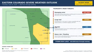
Slight risk for severe storms on the southeast Colorado plains Thursday

Severe storms swept the northeast Colorado plains overnight, producing a brief tornado, hail to more than 3 inches and an 81 mph wind gust, and forecasters expect another round of strong to severe thunderstorms across the eastern plains on Thursday. The NOAA Storm Prediction Center has placed the southeast plains — including Eads, Lamar and the southern edge of Cheyenne County — in a slight risk for severe storms, level 2 of 5, with damaging wind the main concern.
After a dry start, storms are expected to develop along the higher terrain by mid-afternoon and push east across the plains into the evening. Strong outflow winds to around 65 mph are the leading threat, with hail up to an inch or so possible — and up to 1.5 inches if storms organize along a cold front sliding south across the plains. This article was prepared early Thursday morning, and conditions may change as the day unfolds.
At a glance: Thursday's severe weather risks
©
Source: NOAA Storm Prediction Center Day 1 outlook and National Weather Service offices in Pueblo and Goodland — issued the morning of June 25, 2026. Times are Mountain.
(Kiowa County Press)
What the Storm Prediction Center is saying
In its Thursday morning outlook, the Storm Prediction Center in Norman, Okla., placed the southeast Colorado plains in a slight risk for severe storms, level 2 of 5, with a broader marginal risk, level 1, covering most of the rest of eastern Colorado. Unlike recent days, no higher-end enhanced risk was posted anywhere in the state. Eads and Lamar sit within the slight-risk area, with Cheyenne Wells along its northern edge. Forecasters said wind and hail would be the main threats, with the severe potential hinging on how much the atmosphere can destabilize behind morning clouds and rain.
Timing and where the storms are most likely
The National Weather Service office in Pueblo, which covers the southeast plains including Kiowa, Prowers, Bent, Otero, Crowley and Baca counties, expects scattered storms to blossom over the higher terrain by mid-afternoon and move east across the plains. With higher cloud bases, strong outflow winds to around 65 mph would be the primary hazard, along with isolated large hail to about an inch. Forecasters added that storms could also fire along a cold front sagging south across the plains, where at least transient supercells capable of 1.5-inch hail and 65 mph winds are possible. Most storms are expected to wind down during the evening.
The Goodland, Kan., office, which covers Cheyenne, Kit Carson and Yuma counties, said the overnight severe threat had diminished by early Thursday as a line of storms pushed southeast, but that another round of strong to severe storms was possible in the afternoon, with the best chances over eastern Colorado. Forecasters there warned that days of heavy rain have saturated the ground and kept flash flooding a concern; a flood watch was in effect through Thursday evening for much of the area, though not Cheyenne County, where Cheyenne Wells sits.
What happened Wednesday
Wednesday's severe weather struck the far northeast corner of Colorado, well away from the southeast plains. The National Weather Service confirmed a brief tornado near Fleming in Logan County and logged a peak wind gust of 81 mph near Akron in Washington County. Hail was widespread across the northeast, the largest a 3.2-inch stone — bigger than a baseball — near Dailey in Logan County, with 2.5-inch hail near Sterling and in Phillips County. A pair of 1.75-inch hail reports also turned up near Trinidad in the south.
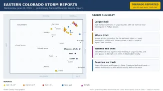
©
Preliminary hail, wind and tornado reports across eastern Colorado on Wednesday, June 24, 2026.
(Kiowa County Press)
For a third straight day, the counties the Press follows most closely — Kiowa, Cheyenne and Prowers — recorded no severe reports, with the storms staying well to the north. All reports are preliminary and subject to National Weather Service review.
Potential impacts
The most likely impacts Thursday are localized and wind-driven. Outflow gusts of 65 mph or higher can snap tree limbs, knock branches onto power lines, briefly cut electricity and kick up sudden blowing dust that drops highway visibility with little warning. Hail of an inch to an inch and a half can dent vehicles, break windows and bruise crops. The tornado threat is low across the southeast plains, but any rotating storm should be watched closely over open country. With the ground already wet in spots, brief downpours could pond water on low-lying roads.
Fire weather and the days ahead
The active, storm-prone pattern is forecast to continue Friday with another chance of strong to severe storms on the plains. Attention then turns to fire weather: the Pueblo office has posted a fire weather watch for Saturday across the mountains and valleys to the west, and says widespread critical fire weather conditions are expected to return across south-central and southeastern Colorado this weekend into early next week as hot, dry and windy weather builds in. Highs climb back toward seasonal levels Friday and into the 90s and around 100 on the plains by the weekend.
Staying safe
A severe thunderstorm or tornado watch means conditions are favorable for dangerous storms to develop over the next several hours — a signal to stay alert and know where you would take shelter. A warning means a dangerous storm is happening or imminent in your area, and you should act right away. Make sure you have a reliable way to receive warnings, such as a NOAA Weather Radio or alerts on your phone, and do not rely on hearing an outdoor siren from indoors.
With damaging wind and hail the main dangers, the safest place is indoors, away from windows. If you can hear thunder, lightning is close enough to strike, so stay inside until at least 30 minutes after the last rumble. Drivers should slow down in heavy rain, watch for sudden gusts and blowing dust, and never enter a flooded roadway. Before storms arrive, secure or bring in loose outdoor items, move vehicles under cover where possible, and check on neighbors, livestock and pets. The latest watches, warnings and timing are available at weather.gov.