Tornado warnings in Kiowa County Friday evening, critical fire weather grips mountains, west slope Saturday

Severe storms swept across the eastern Colorado plains Friday evening, prompting tornado warnings for Kiowa County and producing three reported tornadoes, large hail and damaging wind before pushing into Kansas. By Saturday the pattern flips: the storms give way to hot, dry and windy conditions and the start of an extended stretch of critical fire weather across southern Colorado.
The National Weather Service in Pueblo issued tornado warnings that included Kiowa County around 7:15 to 8:15 p.m. Friday as a rotating supercell tracked near Eads. Three tornadoes were reported across the region — two in Cheyenne County and one in Bent County — along with hail to 1.5 inches near Eads and wind gusts as high as 68 mph.
What happened Friday night
Friday's storms developed over the higher terrain in the afternoon and intensified as they moved onto the plains in the evening — the most active severe weather the region has seen in days. The National Weather Service confirmed three tornadoes: two in Cheyenne County, near Aroya and Firstview, and one in Bent County, near Fort Lyon. The strongest reported wind gust was 68 mph near Firstview, and hail up to 1.5 inches — about the size of a walnut — fell near Eads in Kiowa County. A 58 mph gust was clocked near Lamar in Prowers County.
©
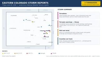
Preliminary hail, wind and tornado reports across eastern Colorado on Friday, June 26, 2026.
(Kiowa County Press)
Unlike recent days, the counties the Press follows most closely were squarely in the action this time, with Kiowa, Cheyenne and Prowers all reporting severe weather or coming under warnings. All reports are preliminary and subject to National Weather Service review.
Tornado warnings for Kiowa County
Kiowa County was placed under two tornado warnings Friday evening. The first, issued at 7:14 p.m. and also covering Bent and Prowers counties, ran until 8 p.m.; a second, for Kiowa County alone, was issued at 7:32 p.m. and ran until 8:15 p.m. Both were tied to a supercell thunderstorm moving across the county near Eads — the same storm that dropped 1.5-inch hail. While no tornado was confirmed on the ground in Kiowa County, a tornado was reported a short distance south, near Fort Lyon in Bent County. A tornado warning means a tornado is indicated by radar or has been spotted, and residents in the warned area should take shelter immediately.
Today: critical fire weather
The severe storm threat exits the area Saturday, replaced by the first day of an extended hot, dry and windy pattern. The Storm Prediction Center confined any severe weather risk to the far northeast corner of Colorado, leaving the southeast plains — including Eads, Cheyenne Wells and Lamar — with no severe storm risk and little or no rain.
©
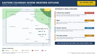
Source: NOAA Storm Prediction Center Day 1 outlook and National Weather Service office in Pueblo — issued the morning of June 27, 2026. Times are Mountain.
(Kiowa County Press)
The National Weather Service in Pueblo warns of critical fire weather across southern Colorado, with afternoon wind gusts to around 50 mph and humidity falling to 12 to 14 percent. A Red Flag Warning is in effect for the mountains and the San Luis Valley to the west, where the least rain has fallen recently. On the plains, recent rainfall may briefly temper the fire danger, but forecasters urge caution with anything that could spark a blaze. Highs climb into the mid 90s to low 100s — near 97 at Eads, 96 at Cheyenne Wells and 102 at Lamar.
Looking ahead
The dry, windy pattern is forecast to persist into next week, with critical fire weather conditions expected each day through at least midweek. The strongest winds — and the greatest fire weather concern — are expected Sunday and Monday, as the pressure gradient tightens between a trough to the northwest and high pressure to the east. Temperatures will stay above seasonal, with highs in the 90s to around 100 on the plains and little chance of rain.
Staying safe
During the dry, windy stretch ahead, avoid any activity that could start a grass fire — dragging chains, parking hot vehicles over dry grass, welding or burning trash — and report any wildfire immediately by calling 911. Even with recent rain, fine fuels can dry quickly under low humidity and strong wind.
When severe storms do return, remember that a watch means conditions are favorable for dangerous storms and a warning means one is happening or imminent — act right away. A reliable way to receive warnings, such as a NOAA Weather Radio or alerts on your phone, is the best way to get advance notice, especially after dark. The latest watches, warnings and forecasts are available at weather.gov.