A wet, hot September pulled Kiowa County out of drought. The mountains are still waiting.

© KiowaCountyPress.net
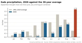
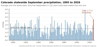
After eight months of almost nothing, September delivered. Eads measured 3.79 inches of rain at the National Weather Service cooperative station, the third wettest September in 119 years of records there and more than June, July and August combined. La Junta had its wettest September since its airport records began in 1945. Statewide, it was the sixth wettest September in 132 years, according to NOAA's National Centers for Environmental Information.
It was also the second warmest September on record for Colorado. That combination, heat and rain together, says a lot about what the month fixed and what it did not.
How wet it was
Colorado averaged 2.72 inches of precipitation across the state in September, against a 30-year average of 1.49. Only 2013, 1941, 1961, 1938 and 1940 were wetter. The Arkansas drainage basin, the climate division that covers southeast Colorado, averaged 3.15 inches, its second wettest September since 1895, behind only 1941.
©
The rain came in waves, with one storm driving each. The first was on September 8 and 9, when the Press's weather station in Eads caught just over an inch. The second was September 20 and 21, when a slow line of thunderstorms dropped 2 inches at the La Junta airport and 0.9 inches in Eads. The third came September 24, when 1.61 inches fell at the Eads cooperative station and 1.44 inches at the Press station, the biggest single day of the month.
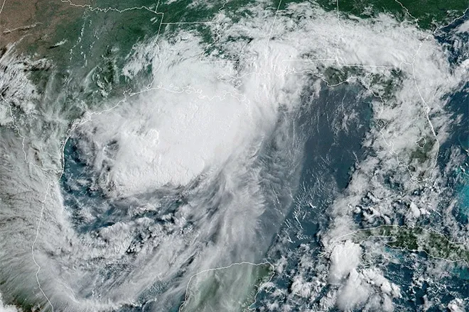
Then the remnants of Hurricane Polo arrived from the Pacific on September 29 and stayed through October 1. The National Weather Service office in Pueblo tallied the storm totals on the morning of October 1: 4.41 inches a mile west of Las Animas, with 4.3 of that between 6 p.m. September 30 and 8 a.m. October 1; 3.61 inches at Towner; 3.54 inches southwest of Walsh; 3.47 inches at La Junta; 2.98 inches at the Lamar airport. Around Eads the totals ran 1.5 to 2 inches, with 1.95 inches southwest of town and 1.60 inches west-northwest. South of Haswell measured 1.59 inches, and north of Chivington 1.51.
©
Not every station was soaked. Colorado Springs finished September below its average. Grand Junction landed in the middle of its record. But Pueblo had its fourth wettest September since 1954, Denver International Airport its fifth wettest since the airport opened, and Alamosa its second wettest since 1948. Near Ignacio, 2.85 inches fell in a single day, a rain the Colorado Climate Center called a greater-than-100-year event.
What it did
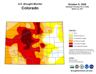
The clearest result is on the drought map. On August 25, 4 percent of Colorado was drought-free and 79 percent was in severe drought or worse. On the U.S. Drought Monitor map of October 6, the first to count the Polo rain, 16 percent of the state is drought-free and 55 percent is in severe drought or worse. Extreme drought fell from 48 percent of the state to 33, and exceptional drought from 14 percent to 8. The Drought Monitor's authors called it some of the largest one-week improvement of the season, enough for two-category upgrades in parts of southeast Colorado, as the Press reported October 8.
Kiowa County is out of drought altogether. In late August the whole county was in severe drought, more than half in extreme drought and a sixth in exceptional drought. On the October 6 map, 65 percent of the county has no drought or dryness at all, and the rest is abnormally dry, the lowest category. Bent County is entirely clear. Cheyenne County is 95 percent clear and Prowers 90 percent. Baca and Crowley counties are abnormally dry but out of drought. The exceptions in the region are to the west: Pueblo County still has 53 percent of its area in extreme drought, and Las Animas County 23 percent.
The rivers felt it too. The Purgatoire River, which drains the country south of La Junta and Las Animas, ran at about 55 cubic feet per second for most of September and hit 1,230 on October 1. The Arkansas at Lamar averaged 46 cubic feet per second in September, nearly double August, and peaked at 214 on September 26. Most of the Polo runoff ended up behind John Martin Dam. The reservoir held 19,975 acre-feet on September 29, close to the lowest level in its records, as the Press reported in September. By October 6 it held 30,946 acre-feet, and by October 10, 31,920. One storm added roughly 12,000 acre-feet, a 60 percent gain, according to the Colorado Division of Water Resources gauge at the dam.
©
Farther up the river the story is thinner. The Arkansas above Pueblo Reservoir averaged 59 cubic feet per second in September, less than it did in August. The big mountain reservoirs that supply the Front Range and the Western Slope did not get a storm like Polo. That is why the Drought Monitor still shows all of Eagle County, 88 percent of Summit County and 80 percent of Pitkin County in exceptional drought, and why the state entered the new water year on October 1 with 71 percent of its area still in drought.
What it cost
Some of the rain came with hail. On the evening of September 20, a Sunday, storms over Kiowa and Cheyenne counties dropped hail the size of baseballs north of Eads and near Wild Horse and Kit Carson, 3-inch stones south of Brandon, and, by photographs shared with the weather service, 4-inch hail south of Chivington. The night before, flash flooding closed part of U.S. Highway 385 north of Burlington. The Polo storm sent water across Colorado Highways 78 and 165 near Beulah and San Isabel on September 29, and flooded county roads around Tribune, Kansas, just east of the state line, on October 1.
The timing was awkward for harvest. In the U.S. Department of Agriculture's October 5 crop progress report, Colorado farmers had 5 days suitable for fieldwork in the week ending October 4, down from 5.8 the week before. Corn harvest stood at 5 percent complete against a five-year average of 15, sorghum at 2 percent against 12, and winter wheat planting at 61 percent against 74. On the other side of the ledger, 30 percent of the state's topsoil was rated adequate or surplus, up from almost none at midsummer, and winter wheat that is in the ground has moisture to come up in.
The same report shows how far there is to go. Seventy percent of topsoil and 66 percent of subsoil were still rated short or very short. Nearly half of Colorado's pasture and range was rated poor or very poor.
Why the heat matters
September averaged 62.8 degrees statewide, a tenth of a degree short of the record set in 2019. Eads hit 101 on September 7 and was still in the 90s on September 8, 9 and 11, between the rains. Warm air pulls moisture back out of the ground, so a wet month in a hot September does less lasting good than the same rain in a cool one. The water year that ended September 30 was the warmest in Colorado's records by more than 2 degrees, and even with September's help it finished among the 20 driest.
In Eads, the rain gauge tells the same story. Through August, the cooperative station had measured 6.81 inches for the year, 54 percent of normal. September lifted that to 10.60 inches, 79 percent of normal through nine months. The deficit shrank. It did not close.
Outlook
The federal Climate Prediction Center said October 8 that El Niño strengthened again last month, with sea-surface temperatures in the key stretch of the Pacific now 2.1 degrees Celsius above normal and parts of the eastern Pacific more than 4 degrees above. The center gives an 83 percent chance that the event is the strongest in records going back to 1950 during October through December, and better than an 83 percent chance that it stays strong or very strong through next March. The Polo rain itself was tied to the eastern Pacific hurricane season that El Niño feeds, and the center expects that connection to continue.
The center's outlooks for October and for October through December, both issued September 30, call for drought to remain but ease across most of Colorado, with removal likely along the Arkansas valley and parts of the eastern plains, while drought persists from Wyoming north. The October through December precipitation outlook tilts toward wetter than normal across the Four Corners and the southern and central Plains. NOAA's winter outlook comes October 15.
The near term is dry. The weather service forecast for Eads has sunny skies and highs in the mid 80s through Monday, with winds gusting to 45 mph Sunday night, a chance of showers Wednesday and Wednesday night, and a cooler, windy Thursday with a high near 64.
For Kiowa County, September did what a month of rain can do: it ended the drought on the map, filled stock ponds and gave the wheat a start. What it could not do is refill John Martin, or Blue Mesa, or the snowpack that was never there last winter. That job belongs to the winter ahead, and to the El Niño everyone is watching.