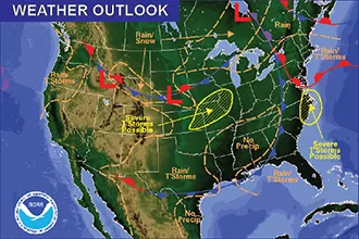
Thunderstorms Possible for Memorial Weekend

A risk of thunderstorms – some potentially severe – returns Friday to kick off the Memorial Day weekend.
Temperatures will be in the 70s.
For west-central Colorado, a red flag warning will be in place due to dry fuels, humidity under 15 percent, and winds exceeding 25 mph, with gusts to 45 mph expected. Showers are possible with occasional lightning. Open burning and other outdoor activities that could spark fires are discouraged.
The potential for storms returns Saturday, shifting further into southeast Colorado as a cold front drops across the plains. High temperatures will dip to the 60s and 70s through Sunday.
Monday kicks off a potentially active week of weather. Temperatures return to the upper 70s, and a low-pressure system builds over the Baja Peninsula, helping draw moisture into the Four Corners area. Afternoon and evening thundershowers are a possibility.
As the week progresses, expect a warming trend, with highs reaching the 70s and 80s throughout the period.