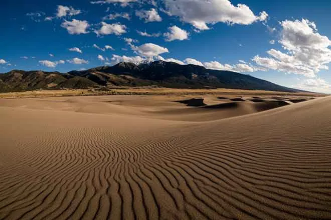
After the water: a collapsed bridge, a river rising again at the Four Corners, and Lake Powell 17 feet off its record low

Wednesday morning the San Juan River at Pagosa Springs was back inside its banks, the flood warnings for the Animas at Durango and the Rio Grande at Alamosa had expired, and the sky over the San Juan Mountains was clear for a second day. The accounting that began on Election Day now has numbers in it. The Piedra River bridge on U.S. 160 lost its piers and must be rebuilt. New Mexico counts 604 homes damaged or destroyed before the second storm and expects 2,000. Arizona has two dead in Flagstaff. And the San Juan at the Four Corners, where the last of the storm's water is draining out of three states, was rising again Tuesday night.
What the rivers did
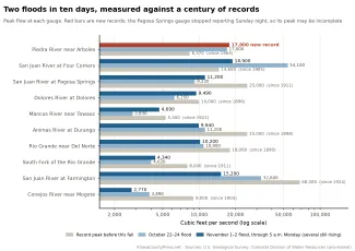
In the mountains the second storm was the larger flood. The Piedra near Arboles reached 17,800 cubic feet per second Sunday night, more than twice its record before this fall. The Mancos near Towaoc reached 5,490 early Tuesday, past the 5,300 of 1941 and the highest since 1921. The San Juan at Pagosa Springs crested at 16.81 feet Sunday evening, a foot below the 1911 flood and the second highest stage on record. The Animas at Durango peaked at 13,000 cubic feet per second Monday morning, third highest since 1898 and highest since 1927. The Dolores ran its second highest since 1896 and the Rio Grande near Del Norte its third highest since 1890.
©
On the lower San Juan the second flood was the smaller one, because Navajo Reservoir caught most of what came off the mountains. The San Juan at Farmington, Shiprock and Bluff all crested below their late-October peaks. Then the Four Corners gauge, between Shiprock and Bluff, rose all Tuesday afternoon to 48,300 cubic feet per second at 9:15 p.m., with Shiprock upstream still falling, and the weather service now expects the river at Bluff, Utah, back above flood stage Wednesday evening. All figures are provisional.

©
What it cost in Colorado
Governor Jared Polis's office issued its first accounting of the second flood Tuesday. The piers of the U.S. 160 bridge over the Piedra, 18 miles west of Pagosa Springs, collapsed, and the Colorado Department of Transportation will rebuild it while it installs a temporary bridge. Colorado 151 washed out again, a culvert failed on Colorado 17, a bridge on Archuleta County Road 202 was destroyed, and a gas pipeline near the Piedra was damaged. Cell service in Archuleta County, cut Sunday, was back by Tuesday. The National Guard rescued more than 50 people. State engineers report some damaged dam spillways.

CDOT counts at least five damaged places on U.S. 160 between Pagosa Springs and Bayfield, a sinkhole and deep slides over Wolf Creek Pass, and the Rio Grande bridges at Del Norte and Monte Vista closed by high water. "Our first order of business is to get them open before winter hits," executive director Shoshana Lew said. U.S. 160 reopened through Pagosa Springs Tuesday but stays closed from mile 121 to 139 and over Wolf Creek Pass, leaving U.S. 84 as the town's one way out.
Pagosa Springs lifted most evacuation orders Tuesday afternoon. Homes on Hermosa and San Juan streets, where a house fell into the river Sunday, stay evacuated, and the town is telling people to stay out of the river after sewage discharged near the First Street bridge. In La Plata County, 73 people slept in shelters Sunday night after six mobile home parks were ordered out. The governor's October 31 request for a presidential disaster declaration counted 27 million dollars in public damage; his office said that leaves out private property and everything from Sunday. No decision had been announced Wednesday morning.
The drought map and the river
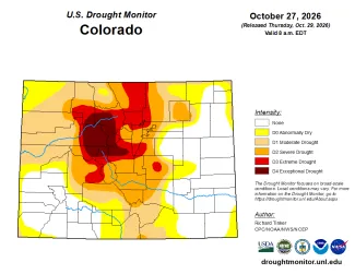
The Drought Monitor released October 29, drawn before the second storm, remains the map of record until Thursday. It showed 34.9 percent of Colorado free of drought, up from 8.9 percent at the end of September, and severe drought or worse down to 28.5 percent of the state from 58.2. Archuleta, San Juan and Kiowa counties were entirely clear. Thursday's map will be the first to include the second storm.
©
Lake Powell took in 1.28 million acre-feet in October, second only to October 2006 since the dam closed. The second storm reached the lake November 2, when inflow hit 41,000 cubic feet per second against a release of 6,500. The lake has gained 129,000 acre-feet in the first two days of November, a quarter of a normal month, and stands 15 feet above October 1 and nearly 17 feet above the record low of September 15, at 26 percent of capacity. Navajo Reservoir took in more than 100,000 acre-feet in a single day Monday and rose 13 feet in two days, to about 78 percent full after starting October at 50. Reclamation's November study, due November 13, will say what this changes.
New Mexico and Arizona
New Mexico's governor asked Monday for a major disaster declaration for the October 22 to 30 flooding: 604 homes damaged or destroyed so far, 353 of them destroyed or with major damage, more than 5,000 people ordered out in San Juan County, 36 rescued from the water, 190 still in the Red Cross shelter in Farmington, and total damage expected to pass 200 million dollars. That count stops before the second storm, which put the La Plata River into homes north of Farmington and washed out New Mexico 170.
In Arizona the Salt River near Roosevelt reached 143,000 cubic feet per second Monday, equal to the 1993 record, and the Verde ran its third highest since 1891. The Little Colorado at Winslow reached 25.3 feet, major flood stage, but the 40-foot crest forecast Monday never came, no overtopping of the levee was reported, and the town's evacuation orders were lifted Tuesday. Two men were found dead in Flagstaff floodwaters, helicopters rescued at least 27 people around Sedona, and Governor Katie Hobbs declared a statewide emergency. The Salt River Project's reservoirs above Phoenix are 68 percent full, against 54 percent a year ago, and about 40,000 cubic feet per second was flowing down the normally dry Salt River bed through Phoenix Wednesday.
What comes next
A fast, cold system crosses Colorado Wednesday afternoon and night with 4 to 10 inches of snow on the central mountains and rain on the plains Thursday morning. After that every forecast office from Phoenix to Pueblo has the same outlook: dry, warming and quiet into next week. The Rio Grande at Alamosa is expected to touch minor flood stage Wednesday evening as the last of the valley's water arrives.