Colorado snowpack shows modest accumulation after a dry January
After a strong early season, January brought drier than normal conditions throughout most of the state, leading to a decrease in snowpack percentages and decreased streamflow forecasts. As of February 5, statewide snow water equivalent (SWE) is at 90 percent of median, 5 percent lower compared to early January, reflecting a muted accumulation period. January precipitation continues at below normal levels at 77 percent of median an improvement from December’s 69 percent of median.

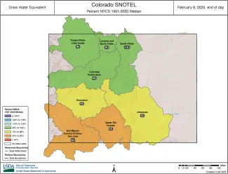
Colorado river basin snow water equivalent as of February 8, 2025 - USDA-NRCS
Water year to date precipitation as of February 1 is below normal at 91 percent. The January storm cycle was largely uneventful with modest accumulations. The average SWE delta from January 1 to February 6 is 2 inches with the highest SWE delta at the Tower SNOTEL showing 7.9 inches of SWE for this period. Compared to this time last year most basin snowpack conditions are slightly higher except for the combined San Miguel-Dolores-Animas-San Juan River basin at 66 percent of median SWE, a 10 percent drop from this time last year. Reservoir storage remains relatively unchanged, with 94 percent of median statewide as of the end of January. This is a slight decline from 100 percent of median this time last year. Reservoir inputs and outputs have remained steady, and no significant changes are expected until spring runoff begins. Streamflow forecasts have decreased since January, now at 89 percent of median, down from 98 percent at the start of the year. This reflects the persistent dry conditions through January.
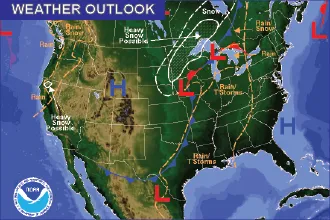
January saw significant temperature swings statewide. A sharp cold spell in mid-January set new record lows. This was followed by record high temperatures in late January and early February. Snowpack and streamflow forecasts will remain sensitive to upcoming storm activity, particularly in southern basins where conditions have continued to decline. Near term conditions from NOAAs 6-10 day outlook suggest mid-February may bring increased precipitation statewide, however January’s deficits could limit overall recovery.
Looking ahead, there are still roughly two months, give or take, until peak SWE, depending on location. Late season storms can still have significant impact, and upcoming precipitation plays an important role in shaping spring runoff. To stay informed, water users can explore Basin Reports for precipitation, SWE, reservoir storage and streamflow data at the basin level (Basin Reports). For real time, station specific data, the RG Lite Tool offers a mobile friendly way to track SNOTEL data from standard SNOTEL elements to extended sensor data including soil moisture where available (RG Lite Tool).


