Feds, state and private landowners designate 2.7 million acre Great Salt Lake Sentinel Landscape
(Utah News Dispatch) A sweeping, unique approach to land management and conservation is headed to Utah in the shape of the 2.7 million acre Great Salt Lake Sentinel Landscape.
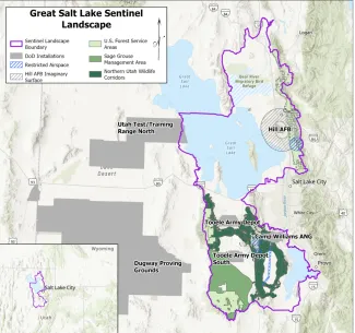
Spanning the final stretch of the Bear River, the Bear River Migratory Bird Refuge, the entire southern arm of the Great Salt Lake, Hill Air Force Base, Tooele Army Depot, Camp Williams, part of the Oquirrh Mountains, the Tooele Valley, and all of Utah Lake and its western shore, the Great Salt Lake Sentinel Landscape brings together a handful of state and local land managers to protect undeveloped land near military installations.
Basically, a sentinel landscape seeks to create a buffer zone around the three main military installations in northern Utah, often working with private landowners and land managers to create conservation easements.
“A lot of the Great Salt Lake Sentinel Landscape objectives are centered around the Salt Lake ecosystem, wildland fire, wildlife habitat and encroachment,” said Tyler Smith, the sentinel landscape’s coordinator and former commander of Camp Williams.
©
A map of the Great Salt Lake Sentinel Landscape. (Credit: U.S. Department of Defense)
The Great Salt Lake Sentinel Landscape boasts more than 30 federal, state, local and private partners, including the Bureau of Land Management, Department of Defense, U.S. Forest Service, Utah Department of Natural Resources, Utah Trust Lands Administration, and Utah Division of Indian Affairs.
Eagle Mountain, Herriman and Layton are all listed as partners, as are The Nature Conservatory, Ducks Unlimited, Bear River Land Conservancy, and National Fish and Wildlife Foundation.
“It brought together these like-minded organizations that have a shared interest, and it’s going to help us become even more productive and efficient with what we’ve already been doing” on the Great Salt Lake, said Smith.
The Great Salt Lake Sentinel Landscape is one of five new designations totaling almost 10 million acres in Utah, New Mexico, California, Hawaii and Pennsylvania.
‘Tremendous opportunities’: What are sentinel landscapes?
The 1990s and early 2000s brought increased growth in rural communities-turned-suburbs around the country, sometimes in once remote areas that housed military installations. Farmland and vacant lots turned into subdivisions, sometimes pushed right up against military bases — a prime example is the growth in Utah and Salt Lake counties closing in on Camp Williams.
In the early 2000s, Congress passed a law that opened up funding for the Department of Defense to work with state and federal land management organizations and private landowners to pass conservation easements and stop encroachment. And in 2013, the U.S. Departments of Interior, Defense and Agriculture signed an agreement to create the sentinel landscape program.
“It has mutual benefits not only to the military but also to the civilian population because having some offset provides better safety and better quality of life,” said Smith.
A sentinel landscape doesn’t actually mandate anything for private landowners. Smith said prior agreements are honored — for instance, if a developer already has a subdivision approved within the landscape’s boundaries, nothing will stop that.
Other landowners or developers are encouraged to participate in the program, but nothing is compulsory. Smith shared an example of a landowner near Camp Williams who planned to subdivide and build homes right on the border of the camp.
With funding from the Department of Defense, the nonprofit Conservation Fund purchased the land and deeded it to Herriman City, which then restricted development and turned the parcel into a network of trails.
“We just ask landowners to consider it. In my opinion, being in a sentinel landscape boundary is a bonus. I would think it enhances the value of the land. If you’re in a sentinel landscape, you’re in an area that’s committed to practicing sound land management,” he said. “Obviously, landowners will always maintain their rights. But there are tremendous opportunities here.”
When encroachment goes untended, it can create problems for both landowners and the military installation. Residents might have to endure frequent explosions, gunfire or the roar of jet engines. In Las Vegas, radios used at a race track built next to Nellis Air Force Base can interfere with aircraft communications. When the Army developed a new bullet that traveled further distances, land near a shooting range at Pennsylvania’s Fort Indiantown Gap suddenly became unsafe.
Sentinel landscapes, Smith said, are the answer.
“It helps identify those factors and come up with nature-based solutions that work for everybody,” he said.
Utah News Dispatch is part of States Newsroom, a nonprofit news network supported by grants and a coalition of donors as a 501c(3) public charity. Utah News Dispatch maintains editorial independence. Contact Editor McKenzie Romero for questions: info@utahnewsdispatch.com. Follow Utah News Dispatch on Facebook and Twitter.


