Heat advisory Monday as Lamar soars to 108 before storm chances build in Prowers County

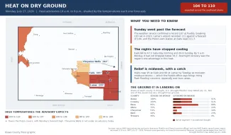
Lamar faces the hottest day of the week Monday, with a forecast high near 108 degrees under a heat advisory, before thunderstorm chances build and highs ease back to around 100 through midweek.
The National Weather Service in Pueblo has issued a heat advisory for the Lamar area and Prowers County from 10 a.m. to 9 p.m. Monday. Skies will be mostly sunny with light and variable winds becoming east at 5 to 10 mph in the afternoon. Monday night brings a 30 percent chance of showers and thunderstorms, mainly before midnight, with increasing clouds and a low around 68.
©
“Another hot day is in store,” Stephen Hodanish, a meteorologist with the National Weather Service in Pueblo, wrote of Monday in Sunday’s Area Forecast Discussion. “I have issued another heat advisory for most of the plains for tomorrow.”
Heat peaks Monday, lingers all week
Monday’s 108-degree forecast would make Lamar one of the hottest spots in the state as a heat dome parked over the region peaks before slowly retreating south. Even as a weak boundary brings better storm chances Tuesday and Wednesday, highs in Lamar are expected to hold at or near 100 degrees every day through Friday.
With a plume of monsoonal moisture over Colorado, forecasters caution that any storm through midweek could produce localized heavy rain. No fire weather warnings are in effect for Prowers County, though hot afternoons and low humidity will keep fire danger a concern until rain arrives.
Lamar, Colo. — Five-day forecast (July 27-31)
Source: National Weather Service, Pueblo — Issued July 26, 2026
| Period | Sky Conditions | High/Low | Wind |
|---|---|---|---|
| Monday | Mostly sunny and hot | 108 | Light and variable, becoming east 5-10 mph in the afternoon |
| Monday Night | Increasing clouds; 30% chance t-storms before midnight | 68 | East-northeast 5-15 mph, becoming north-northwest |
| Tuesday | Mostly cloudy, then sunny and hot | 100 | North-northwest 10-15 mph, becoming east-southeast |
| Tuesday Night | Mostly cloudy; 30% chance showers and t-storms before 3 a.m. | 66 | East-southeast 10-15 mph, becoming north-northwest 5-10 mph |
| Wednesday | Mostly sunny and hot; 20% chance p.m. t-storms | 100 | North-northwest 5-15 mph, becoming south-southeast |
| Wednesday Night | Mostly cloudy; 30% chance t-storms before midnight | 67 | South 5-10 mph |
| Thursday | Sunny and hot; slight chance p.m. t-storms | 101 | West around 5 mph, becoming north in the afternoon |
| Thursday Night | Partly cloudy; 30% chance t-storms before midnight | 66 | Northeast around 5 mph, becoming west-northwest |
| Friday | Sunny and hot | 100 | North 5-10 mph, becoming east in the afternoon |
| Friday Night | Partly cloudy | 64 | East 5-10 mph |
(Kiowa County Press)
Tuesday and Wednesday
Tuesday will start mostly cloudy before turning sunny and hot, with a high near 100 and north-northwest winds of 10 to 15 mph becoming east-southeast in the afternoon. A 30 percent chance of showers and storms follows Tuesday night, mainly before 3 a.m., with a low around 66.
Wednesday brings a 20 percent chance of afternoon storms under a mostly sunny sky with a high near 100, followed by a 30 percent storm chance Wednesday night and a low around 67.
Extended outlook
Thursday will be sunny and hot with a high near 101 and a slight chance of afternoon storms; a 30 percent chance of storms follows Thursday night. Friday looks sunny and hot with a high near 100.
Looking further ahead, the Climate Prediction Center’s outlook issued Sunday favors above-normal temperatures and below-normal precipitation for Colorado Aug. 1-5, with above-normal temperatures continuing to be favored Aug. 3-9, suggesting heat will rebuild across the eastern plains heading into early August.
With Monday’s heat advisory in effect, residents are urged to drink plenty of fluids, stay in air-conditioned spaces when possible, limit strenuous outdoor activity during the afternoon, and check on relatives and neighbors. Never leave children or pets unattended in vehicles.