Kiowa County under the heat event's highest advisory range Monday after Sunday ran past forecast

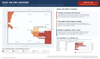
Kiowa County and other parts of southeast Colorado are under a heat advisory again Monday, and the range the National Weather Service attached to it — 104 to 110 degrees — is the highest it has stated at any point in this heat event. It follows a Sunday that ran hotter than forecast and produced a confirmed record at Pueblo.
What Sunday did
The Pueblo office issued a record event report at 6:38 p.m. Sunday stating that “a record high temperature of 107 degrees was set in Pueblo, Colorado today,” breaking the previous July 26 record of 103 degrees set in 2023. It was the only record report from the three weather service offices covering this region; Goodland and Denver/Boulder issued none. The Press reported Sunday that forecasters had said a few records could fall.
Lamar Municipal Airport recorded 111 degrees at 4:20 p.m., two above the 109 forecast for the day. La Junta reached 108 at 5:30 p.m., Burlington 108 at 5 p.m. and Springfield 106 at 4:15 p.m. Colorado Springs recorded 97 and Alamosa 92. Those are hourly airport observations rather than official climate maxima.
©
The Press's own weather station at Eads recorded 111.7 degrees at 2:30 p.m., though official readings are likely to be several degrees coolers. The forecast had been 106. As reported Sunday, that station is not a NOAA climate observation and its readings cannot be measured against the cooperative station's records. Whether Eads set a record for the date will be determined with official NWS records are available.
Monday morning did not cool the way the weekend did
Saturday, the Press reported that the region held one advantage in this heat: overnight lows in the mid-60s. It also reported that the weather service's warning criteria elsewhere account for nighttime lows staying at or above 75 degrees, described then as a threshold this region was not expected to reach.
The Press station at Eads fell to 67.5 degrees Saturday morning and 69.0 Sunday. By about 5 a.m. Monday it had not fallen below 76.7. Lows Monday night are forecast back into the 60s: 66 at Eads, 64 at Cheyenne Wells and 69 at Lamar.
Where the advisories are Monday
A single advisory issued at 1:40 a.m. covers seven forecast zones — Crowley County; La Junta and Otero County; western Kiowa County; eastern Kiowa County; Las Animas and Bent County; Lamar and Prowers County; and Springfield and Baca County — from 10 a.m. to 9 p.m., for high temperatures of 104 to 110.
Three other Pueblo advisories run the same hours: 100 to 106 in the Pueblo vicinity below 6,300 feet, 98 to 103 at Canon City and eastern Fremont County, and 94 to 100 in El Paso County and Colorado Springs. A fifth, from the Grand Junction office, covers western Colorado and eastern Utah until 6 a.m. Tuesday for “high temperatures of 100 to 107 and warm night time lows.” Cheyenne County, covered by the Goodland office, was under an advisory Sunday but is not Monday.
Forecast highs retrieved at 5:05 a.m. Monday call for 105 degrees at Eads, 102 at Cheyenne Wells and 109 at Lamar. The Pueblo office's area forecast discussion, issued at 1:21 a.m., says temperatures will “quickly warm into the 90s through mid morning across the plains once again,” topping out between 105 and 110 across the lower Arkansas River valley.
The ground it is landing on
Not one of the seven counties the Press follows most closely — Kiowa, Prowers, Cheyenne, Bent, Otero, Crowley and Baca — has any drought-free ground. In Kiowa County 99.8 percent is in severe drought or worse and 51.4 percent is extreme or exceptional. Crowley is at 100 and 51.4 percent, Baca 95.1 and 68.4, Otero 75.2 and 22.9, Cheyenne 51.3 and 10.4, Bent 44.3 and 23.4, and Prowers 35.1 percent in severe drought or worse with none beyond it. Those figures come from the U.S. Drought Monitor map dated July 21, which the Press reported on Friday. Nationally the same map places 65.2 percent of the lower 48 in at least abnormal dryness.
That map predates this weekend's readings and is valid only through Monday; a new one publishes Thursday, so the effect of the past five days is not yet in it. Rainfall at Eads since July 1 stood at 0.96 inches Monday morning, against a long-term full-July average of 2.60 inches.
Storms midweek, and a flash flooding risk on dry ground
Highs are forecast to ease to 95 at Eads, 93 at Cheyenne Wells and 99 at Lamar on Tuesday, and to hold near there Wednesday. Among the Pueblo office's key messages is that monsoonal moisture increases areawide through the middle of the work week, “bringing increasing coverage of daily showers and storms and increased flash flooding concerns, especially for burn areas,” followed by a drying trend late in the week. Those storms would arrive on the same parched ground described above.
The national picture
Nineteen states carried at least one heat product Monday morning — 93 heat advisories, 66 extreme heat warnings and three watches. Illinois had 11 extreme heat warnings, Kansas, Nebraska and Missouri eight each, and Iowa seven. The highest heat index cited in any of them was 119, in Nebraska and Iowa. Colorado has five products, all advisories, and no extreme heat warning anywhere in the state. As Saturday's article explained, the eastern products are expressed in heat index values while Colorado's are plain air temperature, so the two sets of numbers are not directly comparable.
Heat safety guidance — the signs separating heat exhaustion from heat stroke, who is most at risk, livestock panting scores and Colorado's agricultural heat rules — was covered in detail in Saturday's article and is not repeated here.
Current watches, warnings and advisories are available at weather.gov.