As Marco fizzles, eyes in Texas and Louisiana look toward Laura
(The Center Square) – While Tropical Storm Marco weakened over southeast Louisiana, officials were watching Monday evening to see if Tropical Storm Laura would be as strong as feared once it entered the Gulf of Mexico.
“Marco has continued to fizzle,” Louisiana Gov. John Bel Edwards said. “All eyes from this point forward will be on Laura.”
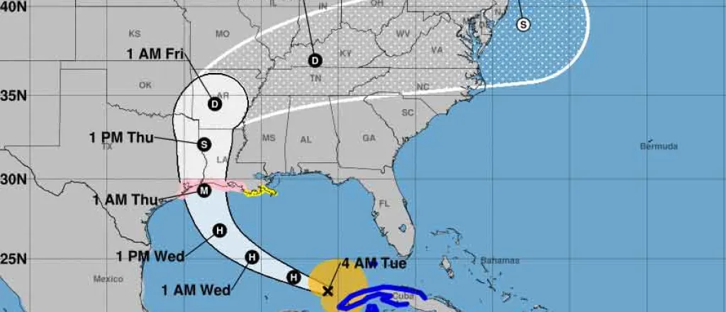
Forecasters currently expect Laura to make landfall late Wednesday or early Thursday near the Texas-Louisiana border as a strong category two hurricane or a weak category three, with possible sustained winds of more than 100 miles per hour. It would be the first category three to hit Louisiana since Rita in 2005, and it is following a similar path.
“This is going to be a very large, very powerful storm,” Edwards said.
Unlike Marco, which fell apart Monday due to changing winds, forecasters so far see little reason for Laura to weaken once it clears Cuba and enters the warm water of the Gulf of Mexico.
The entire Louisiana coast is under a storm surge watch, and there could be as much as 11 feet of storm surge from the Texas border to the Atchafalaya River, forecasters say. Tropical storm-force winds could be felt from Houston to Baton Rouge, possibly as early as Wednesday morning.
Laura is expected to bring five to 10 inches of rain and as much as 15 inches in some isolated areas. The good news is the storm is expected to move quickly, which limits the amount of rainfall.
“She will exit the state out the back door about 12 hours or so after she comes through the front door,” Edwards said. “But five to 10 inches of rain is plenty of rain if the rivers are not emptying as they normally do.”
At 4 p.m. Monday, the center of Tropical Storm Marco was about 15 miles east-southeast of the mouth of the Mississippi River, the National Hurricane Center said in its latest update. The storm was expected to weaken into a depression and move west across Louisiana Monday night and Tuesday. The storm was expected to produce heavy rain and wind gusts over portions of the northern Gulf Coast through Monday evening.
At the same time, Tropical Storm Laura was about 175 miles east of the western tip of Cuba, the National Hurricane Center said. A hurricane watch was in effect from Port Bolivar, Texas, to Morgan City.
A tropical storm watch was in effect from south of Port Bolivar to San Luis Pass, Texas, and from Morgan City to the mouth of the Mississippi River. A storm surge watch was in effect from San Luis Pass to Ocean Springs, Miss.


