Much of Colorado can expect some snow by Christmas morning
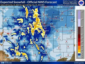
Most of Colorado is predicted see at least a trace of snow by Monday morning, with some northern mountain areas receiving as much as one foot at the highest elevations.
Southeast Colorado, including Kiowa and Cheyenne counties, is on the lowest end of the scale with less than one inch predicted over the next 72 hours. Expected amounts could change as the storm systems evolve.
Two storm systems are expected to bring rounds of snow to the southeast portion of the state through Sunday, with the heaviest snow predicted for the eastern San Juan mountains.
©
Warmer temperatures will result in a mix of rain and snow over the lower elevations, potentially limiting the amount of accumulating snow. In southeast Colorado, high temperatures Friday and Saturday are predicted to approach 60 before falling into the 30s Sunday and Monday.
The exact track of the storm remains fluid, along with how the two systems will interact and potentially impact road conditions over the holiday weekend.
The National Weather Service recommends that people check for forecast updates regularly, and adjust plans accordingly.
For people who must travel, the NWS and emergency managers offer these tips:
- Share your travel plans with friends or family, including your travel route and expected arrival time
- Winterize your vehicle, ensuring fluids are topped off and tires are in good condition
- Ensure you have a full tank of fuel before starting your trip
- Take an emergency supply kit which includes water, food, and warm blankets
- Check road conditions at www.COTrip.org from the Colorado Department of Transportation

