Record rivers, a dozen Colorado counties under emergency and thousands of homes hit in New Mexico: the Four Corners flood

Three weeks after the drought map still had the Rio Grande headwaters in extreme drought and the San Juan basin in severe drought, the remnants of a Pacific hurricane dropped four inches of rain on the San Juan Mountains in two days and sent every river draining them over its banks. By Sunday, Colorado had a disaster emergency in 12 counties, New Mexico had hundreds of water rescues behind it and a federal disaster request in front of it, and the San Juan River had run higher at Farmington than at any time in the National Weather Service's records.
No deaths had been reported in either state as of Saturday.
The rain
The moisture came from Hurricane Trudy, which formed in the eastern Pacific in mid-October. Its remnants drifted into the Four Corners on October 21, and rain fell on the San Juan Mountains for most of two days.
©
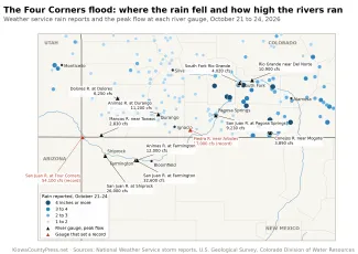
In the two days ending at midnight Thursday, October 22, weather service observers measured 4.80 inches northwest of Los Pinos in Conejos County, 4.73 inches north of Monte Vista, 4.40 inches on Wolf Creek Pass, 4.37 inches southeast of South Fork and 3.90 inches at Cumbres Pass. Pagosa Springs had recorded 3 inches by early Friday. In Utah, a snow survey station west of Monticello had measured 3.8 inches by Thursday morning. The rain fell on ground that September's storms had already wetted.
The rivers
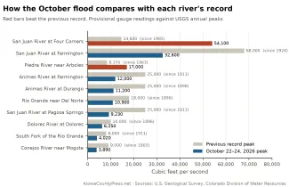
The San Juan River at Pagosa Springs peaked at 9,230 cubic feet per second late Thursday night, the third highest flow in U.S. Geological Survey records that go back to 1911, behind only 1911 and 1927. The Piedra River near Arboles reached 17,000 cubic feet per second, twice its previous record from 1970. The Animas River at Durango peaked at 11,200 Friday morning, fifth highest since 1898, and the Dolores River at Dolores at 6,250, eighth highest since 1896.
Downstream, the San Juan at Farmington hit 32,600 cubic feet per second Friday morning. By flow, that is the fourth largest since the gauge was set in 1924, behind the floods of 1927, 1929 and 1935. By height, the weather service said, it was the highest stage the gauge has recorded. At Shiprock the river crested at about 22 feet early Saturday, more than 6 feet over the 15.5-foot flood stage and the highest stage in that gauge's records, the weather service said. The last reading before the gauge stopped reporting was 21.2 feet at 4 a.m. Saturday, and the Highway 64 bridge was closed when water came over it. Where the San Juan crosses into Utah at Four Corners it reached 54,100 cubic feet per second Saturday afternoon, nearly four times the previous record at a gauge that dates to 1985. Those readings are provisional and the Geological Survey will review them.
©
The storm crossed the Continental Divide too. The Rio Grande near Del Norte peaked at 10,900 cubic feet per second Friday morning, its third highest since 1890, and the South Fork of the Rio Grande at 4,020, second only to 1911, according to Colorado Division of Water Resources gauges.
Colorado
At 8:36 p.m. Thursday, October 22, Governor Jared Polis verbally declared a disaster emergency in La Plata, Archuleta, Montezuma, Dolores, Hinsdale, San Miguel, Ouray, San Juan, Mineral, Alamosa and Rio Grande counties. The declaration activates the state emergency operations plan and authorizes the Colorado National Guard, including aircraft, engineers and unarmed troops, for flood response, evacuation and search and rescue. On Friday he added Conejos County.

© iStock - ArtemSam
About 100 Coloradans had evacuated by Friday and many more were stranded in their homes by floodwater, the governor's office said. Colorado Search and Rescue teams, Department of Natural Resources swiftwater crews, Division of Fire Prevention and Control helicopters, State Patrol troopers and four state emergency management field managers were working with county emergency operations centers and shelters. The state was coordinating with the Southern Ute Indian Tribe, whose reservation takes in the lower Piedra and Los Pinos rivers.
"First responders have tirelessly spent the day rescuing Coloradans stranded due to the flooding and helping people safely evacuate," Polis said Friday. "I urge Coloradans in Southwest Colorado to follow emergency orders and ensure you prioritize your and your family's safety."

The weather service's storm reports from local officials give the texture. The Park Creek bridge on U.S. 160 southwest of South Fork washed away Thursday night with heavy debris in the Rio Grande, and evacuations began from Wolf Creek Ranch to Fun Valley. At Fun Valley, the RV resort west of South Fork, RVs were torn from their sites and became river debris. In Conejos County, water stood 7 feet high on the sides of homes near Cumbres Pass. On the Rio Blanco southeast of Pagosa Springs, a house on County Road 337 was swept away. In La Plata County, County Road 520 lost a culvert and collapsed, and the Animas River through Durango was closed to boating.
The Colorado Department of Transportation closed U.S. 160 over Wolf Creek Pass from Treasure Falls to South Fork, U.S. 160 west of Pagosa Springs and at McCabe Creek in downtown Pagosa, U.S. 550 over Red Mountain Pass between Silverton and Ouray, Colorado 151 at Chimney Rock, Colorado 17 over Cumbres and La Manga passes, and Colorado 112 between Del Norte and Center. U.S. 550 was also closed between Durango and the New Mexico line Friday afternoon when water rose at the Bondad bridge. Current closures are at cotrip.org, and Colorado 211 is taking calls for evacuation, shelter and temporary housing vouchers.
New Mexico
The water that left Colorado arrived in San Juan County, New Mexico, on Friday. Law enforcement reported hundreds of water rescues between Farmington and Bloomfield by Saturday, and the weather service estimated that thousands of homes and buildings had been affected, Governor Michelle Lujan Grisham's office said Saturday. A weather service report Friday morning estimated that as many as 1,500 homes and buildings had been affected, with more than 60 water rescues since Thursday afternoon.
"Families in Bloomfield and Farmington spent the night on rooftops watching the river flood their homes, and our National Guard and State Police crews have been bringing them to safety," Lujan Grisham said. "Right now, our focus is saving lives. If you're told to evacuate, go."
About 58 New Mexico National Guard members, including swiftwater rescue teams, deployed to the county Friday and Saturday. When washed-out roads cut off a family near Chaco Canyon, a Guard team reached them overnight Thursday and evacuated an infant who was having repeated seizures. Floodwater reached the Bloomfield wastewater plant, and untreated sewage flowed into the San Juan River. Shelters opened at McGee Park, which takes pets and RVs, and at two churches in Shiprock.
The governor is preparing a request for a federal emergency declaration for San Juan County. It would be the second in a month, after the state emergency orders signed September 30 for earlier flooding: on Friday she asked for a major disaster declaration for flooding from September 20 to October 2 in 14 counties and three tribal nations, with public damage estimated at 27.1 million dollars. Damage from this week's flood will be assessed when the water recedes.
The storm did not stop at the river. In Cibola County, floodwater closed Interstate 40 in both directions between mile markers 102 and 108 Saturday night, flooded the first floor of the Sky City Casino at Acoma, inundated eight homes at Bluewater Acres and ran through streets in Grants. In McKinley County it closed roads around Gallup and Fort Wingate. Flash flooding reached the east side of Albuquerque and Lincoln County on Saturday.
The Navajo Nation
At Shiprock, the Navajo Nation Commission on Emergency Management declared a state of emergency, and President Buu Nygren concurred, which lets chapters spend emergency funds on shelter, food, water, debris removal and repairs. In an update posted Saturday, Nygren said the San Juan had reached about 23 feet at Shiprock overnight, that homes, roads and infrastructure were flooded and that residents had been stranded on rooftops. New Mexico's congressional delegation said it supports the Nation's request for a federal disaster declaration.
What it means for the water
The same flood is filling reservoirs that were near their lowest levels in decades. Navajo Reservoir on the San Juan gained about 215,000 acre-feet between October 12 and October 24. Vallecito Reservoir north of Durango went from 23 percent full on September 1 to 86 percent. Lake Powell rose five feet in a week. The Press has a separate report on what that does, and does not, change for the Colorado River.
What comes next
More rain fell across the region Saturday and Sunday, and the weather service's flood warnings for the Animas near Farmington and the San Juan at Farmington and Shiprock ran through Sunday afternoon, with rivers expected to fall below flood stage early in the week. Both states will send damage assessment teams in once the water drops. Colorado's road closures can be checked at cotrip.org and New Mexico's at nmroads.com. Anyone in an evacuation zone who needs help can call 2-1-1 in either state.