The second flood: the Piedra sets another record, the San Juan at Pagosa Springs comes within a foot of 1911, and rivers across the Four Corners are still rising Monday morning

Ten days after the Four Corners flood of October 22 and 23, the atmospheric river that forecasters warned about all week put the same rivers back over their banks, and in several places higher than before. As of 5 a.m. Monday, the Piedra River near Arboles had broken the record it set last month, the San Juan River at Pagosa Springs had reached its second highest stage in 115 years of records before its gauge stopped reporting, the Animas at Durango and the Rio Grande near Del Norte were still rising, and the National Weather Service in Grand Junction had a flood warning in effect for five Colorado counties and one in Utah under the heading it reserves for the worst: "Particularly Dangerous Situation."
"Significant and historic flooding is occurring across southwest Colorado and southeast Utah," the office wrote at 4:08 p.m. Sunday. "Many local roads have become flooded and impassable. Some roads have washed out, or collapsed completely. If you live in the warned area, it is recommended to not travel this evening or overnight."
The rivers against their records
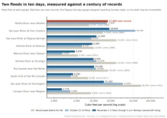
The Piedra River near Arboles, which ran at 17,000 cubic feet per second on October 23, twice its previous record, reached 17,800 at 9:15 p.m. Sunday. That is the new record for a gauge that goes back to 1963. It was still running 12,600 at 4:15 a.m. Monday.
The San Juan River at Pagosa Springs is the river the governor warned about Sunday. The U.S. Geological Survey gauge there reached 16.8 feet and 11,200 cubic feet per second at 8 p.m. Sunday. The stage is more than 4 feet above major flood stage, higher than the 15.0 feet of October 23, and second in records that go back to 1911 only to the 17.8 feet of October 5, 1911. The flow is the third highest ever measured there, behind 1911 and 1927. The gauge then showed the river falling, to 16.1 feet and 10,400 cubic feet per second at 9:30 p.m., and stopped reporting. Rain kept falling for hours after that, so whether a second rise came overnight is not yet known. The weather service's forecast Sunday morning had called for a crest of 22 feet, and its forecasters wrote at 9:27 p.m. that guidance still pointed to "a potentially historic crest." By 4 a.m. Monday the service's river model put the crest near 15 feet around midnight.
The Animas River at Durango was at 9,940 cubic feet per second and still rising at 4:30 a.m. Monday. That is below the 11,200 of October 23 but already the eighth highest flow since 1898, and the river at Durango runs wide and deep enough that the weather service's gauge still read a few inches below flood stage. The Dolores River at Dolores hit 9,490 cubic feet per second at 3:45 a.m. Monday, the second highest since 1896, short only of the 10,000 recorded in October 1911. The Mancos River near Towaoc peaked at 4,690 at midnight, third highest since 1921.
©
East of the divide, the Rio Grande near Del Norte was at 10,200 cubic feet per second and rising at 4:30 a.m., a few hundred below its October 23 peak and the fourth highest reading in 136 years of records. The Pueblo office's warning Sunday evening said major flooding was forecast there Monday, the level at which water reaches the base of the Twin Mountain Bridge on Hanna Lane west of Del Norte. The South Fork of the Rio Grande peaked at 4,340 Sunday evening, above last month's 4,020 and second only to 1911. The Conejos River near Mogote reached major flood stage, 7.0 feet, at 12:45 a.m. Monday at 2,770 cubic feet per second, below last month's peak, with the weather service forecasting a crest of 9.1 feet around dawn Monday, above the 8.5-foot record stage of 1911. The Rio Grande at Alamosa is forecast to reach 10.4 feet late Wednesday night, close to the 10.6-foot record stage of 1949.
Downstream, the San Juan at Four Corners reached 18,900 cubic feet per second at 4 a.m. and was still climbing. That is well above the 14,600 that stood as the record before October 24, when the first flood reached 54,100. The San Juan at Farmington was at 15,200 at 5 a.m., the Animas at Farmington 8,890 and the San Juan at Shiprock 13,200, all rising, with Shiprock forecast to crest at 20.2 feet Monday afternoon, nearly 5 feet above flood stage. All of these figures are provisional, and the gauges that have gone quiet will be checked once crews can reach them.
Why the rivers answered so fast
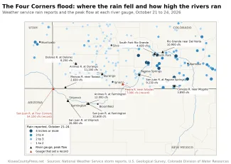
In the valleys the rain was less than the first flood's. Weather service observers reported 2.2 inches northeast of Vallecito and northeast of La Plata by noon Sunday, about 2 inches north of Vallecito, 1.9 near Bondad and 1.6 near Coal Bank Pass, with 3.9 inches west of Monticello, Utah. The Grand Junction office's warning Sunday afternoon put the storm's totals at 1.5 to 3 inches. High on the divide it was a different storm. The Natural Resources Conservation Service's snow survey station at Wolf Creek Summit recorded 4.8 inches of precipitation between late Saturday night and 2 a.m. Monday, with temperatures hovering at the freezing mark, and only about 2 inches of it stayed on the ground as snow. The rest ran off. Last month's storm dropped more than 4 inches on Wolf Creek Pass and the Conejos headwaters over two days.
The difference was the ground. The soils had not dried since October 23, the snow survey stations at Wolf Creek Summit and Red Mountain Pass were carrying 4 to 5 inches of water in about a foot of snow before the rain started, and the rivers had never returned to normal. The weather service's hydrologic outlook on Wednesday expected 1 to 2 inches of rain and rivers below action stage, but warned that saturated hillsides could send rock, mud and debris onto roads. By Sunday afternoon the Pueblo office expected most streams to crest at or slightly above last week's levels, "with moderate to major flooding likely once again."
What it did on the ground
Governor Jared Polis urged residents of Archuleta County and Pagosa Springs Sunday to leave immediately if they were under evacuation orders, saying the San Juan was forecast to run more than 6 feet higher than last weekend. "Do not wait for floodwaters to rise," he said. "Colorado has deployed emergency response resources to help protect communities, but worsening conditions could make rescue operations dangerous." The state warned of significant road closures.
They came. Weather service storm reports from local officials show U.S. 160 closed in both directions from east of Bayfield to Pagosa Springs, mileposts 104 to 136, from 2 p.m. Sunday; Colorado 41 closed north of the Four Corners Monument; Colorado 151 collapsed between Chimney Rock and the old mine site, in the same stretch that washed out last month; and Lightner Creek running over U.S. 160 west of Durango Sunday afternoon. The Grand Junction office said at 4:08 p.m. that flooding was already occurring from Durango to Pagosa Springs, Cortez, Dolores, Dove Creek, Ignacio and Towaoc and across the Utah line to Bluff, Blanding and Mexican Hat. In Utah, U.S. 191 was closed by a debris flow north of the Monticello airport.
©
In New Mexico the water arrived by midday Sunday. The Animas flooded U.S. 550 between Aztec and the Colorado line and the Tico Time RV park near Cedar Hill, where low-lying properties along the river were being evacuated at 1 a.m. Monday. New Mexico 173 collapsed near Turley. New Mexico 170 washed out in two places along the La Plata River, which was reaching the bottom of the Pinon Hills Road bridge west of Farmington and still rising at 1 a.m. Homes near Gobernador Canyon were evacuated. The Rio Chama left its banks at Chama, where homes were evacuated and both U.S. 64 and New Mexico 17 to the Colorado line were closed. Albuquerque's flood warnings covered San Juan, Rio Arriba, Sandoval and Catron counties.
Where the recovery stood when the second storm hit
Saturday, the day before the rain, Polis asked the president for a major disaster declaration for Archuleta and Rio Grande counties from the first flood. Joint assessments had already found nearly $27 million in eligible public damage in those two counties alone: $10.6 million to local roads, bridges and culverts, $8.59 million to parks and recreation facilities, $2.44 million to utilities and $4.16 million in emergency protective measures. About 100 homes in Archuleta County were still inaccessible as of October 29. The state said it mobilized nearly 100 National Guard members in the first flood and rescued 48 people and 31 animals, and that the Southern Ute Indian Tribe will seek federal help on its own. The Federal Highway Administration had released 6.5 million dollars Friday for highway repairs. Much of that work is now under water again.
New Mexico's governor signed 57 emergency orders Wednesday committing $42.75 million to flood recovery, bringing the state's commitment over the past month to nearly 55 million, and said damage in San Juan County and surrounding areas from the first flood could exceed $200 million. The president signed an emergency declaration for New Mexico October 23 but has not approved reimbursement for debris removal and protective measures, Governor Michelle Lujan Grisham said. "We're planning now for the next storm," she said Wednesday. It arrived four days later.
What comes next
The rain is ending. The Grand Junction office said Sunday night that widespread precipitation diminishes Monday morning, with a cold front turning it to snow at pass level and drier weather Tuesday. Winter storm warnings for the San Juans run to midday Monday. But the rivers lag the rain. The Pueblo office expects flooding along the Rio Grande from Monday through Wednesday, especially from South Fork down to Alamosa, and along the Conejos. The San Juan's crest reaches Shiprock Monday afternoon. Tuesday is dry, and a weak system brings a chance of showers Wednesday into Thursday.
Below all of it, Navajo Reservoir took in 81,000 acre-feet between October 28 and November 1 and is 72 percent full, up from 50 percent on October 12. Lake Powell gained another 84,000 acre-feet in the same four days, before the second flood reached it. The Press's account of the first flood and its report on the week between are online. Road conditions are at cotrip.org and nmroads.com, and Colorado 211 handles shelter and evacuation help.