Updated: 3.0 earthquake Monday adds to a busy decade of small quakes in northwest Kansas

© iStock - allanswart
Updated Tuesday, September 29, with a revised location from the U.S. Geological Survey, a smaller quake just before the main one, the Kansas Geological Survey's measurement and more felt reports.
A magnitude 3.0 earthquake struck Graham County, Kansas, at 5:54 p.m. Central time Monday, according to the U.S. Geological Survey. That was 4:54 p.m. in Eads.
The USGS has since revised the quake's location. It now places the quake less than 2 miles southwest of Bogue and about 7.5 miles east of Hill City. The first report had placed it about 3 miles west of Bogue.
About four minutes earlier, at 5:50 p.m. Central time, a magnitude 2.5 quake struck about 5 miles south of Bogue, according to the USGS. No one reported feeling that one.
©
The Kansas Geological Survey, which runs its own network of earthquake instruments in the state, measured the larger quake at magnitude 3.2. Because the survey uses its own instruments, its figures can differ from the USGS.
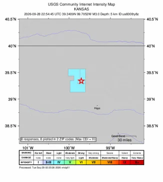
By Tuesday morning, eight people had reported feeling the main quake through the USGS "Did You Feel It?" website. Seven were in the Hill City area and one was in Bogue. Most described weak shaking. The strongest report, from just east of Hill City, described moderate shaking. The Press found no reports of damage.
Weak shaking can feel like a passing truck, and many people do not recognize it as an earthquake, according to the USGS. A magnitude 3.0 is close to the smallest earthquake people usually notice. "Typically, people report feeling earthquakes larger than about magnitude 3.0," the USGS says.
In the USGS catalog, Monday's quake was the second-largest in Graham County in the past 10 years. The largest was a magnitude 3.5 about 6 miles south of Hill City on June 1, 2025. Monday's quake also came two years to the day after a magnitude 2.5 struck about 3 miles south-southwest of Bogue on September 28, 2024.
90 quakes in 10 years
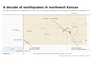
The USGS has recorded 90 earthquakes in northwest Kansas over the past 10 years, including Monday's two. That counts the 18 counties served by the Northwest Kansas Planning and Development Commission, based in Hill City. Nineteen of the quakes measured magnitude 3.0 or more.
Nearly all of them were in the eastern part of the region. Rooks County had 32, Graham County 22, Russell County 9, Ellis County 8, Osborne County 7, Smith County 6 and Phillips County 5. Ten of the 18 counties had none.
Last year was by far the busiest. The USGS recorded 40 quakes in northwest Kansas in 2025, nearly half of the 10-year total. Sixteen of them were in Graham County.
On July 5, 2025, nine small quakes shook the area south and southwest of Hill City and Bogue in less than eight hours. It was the busiest day of the decade. The next day, the Graham County Sheriff's Office said it had no reports of damage, according to the Hays Post.
The largest quake of the decade was a magnitude 4.6 about a mile south-southeast of Zurich in Rooks County. It struck at 3:50 a.m. Central time on June 22, 2019. More than 1,200 people reported feeling it. They included people in Burlington, Holly, Granada and Kit Carson, and a few as far away as Denver and Cañon City. It is the largest Kansas earthquake in the USGS catalog in the past 10 years.
Other notable quakes include a magnitude 3.7 near Natoma in Osborne County on August 22, 2018. On February 2 of this year, 51 people reported feeling a magnitude 2.9 about 4 miles north of Hays.
The quake east of Cheyenne Wells
The only quake of the decade in the western half of the region came this year. On March 28, a magnitude 3.1 struck less than 2 miles northwest of Weskan in Wallace County, Kansas, at 2:31 p.m. Mountain time. That is about 20 miles east of Cheyenne Wells. The Press reported it that afternoon. Eight people have since reported feeling it.
The USGS has never recorded another earthquake of magnitude 2.0 or larger in far northwestern Kansas, west of Oakley.
Closer to home
Kiowa County has small quakes, too. The USGS has recorded 10 in the county since 2016. None was larger than magnitude 2.5, and no one reported feeling any of them.
Three of them, in March 2021, January 2022 and December 2025, were centered within 2 miles of one another, about 10 miles northwest of Eads. The most recent was a magnitude 1.8 about 4 miles southwest of Eads on August 20.
Cheyenne County has had four, the largest a magnitude 2.3 about 12 miles west of Cheyenne Wells in November 2021.
Southeast Colorado also has a fault that has moved in the recent geologic past. Scientists have dug trenches near Haswell to study the Cheraw fault. The Colorado Geological Survey says few faults in the central and eastern United States are known to have broken the ground's surface in an earthquake since the end of the last ice age. The Cheraw fault is one of them.
What causes them
No agency has pinned down what is causing the quakes around Hill City and Bogue. But the Kansas Geological Survey has taken note of them.
In a draft report posted in July, the survey called the Graham County cluster "particularly notable." By the survey's own count, it included four quakes of magnitude 3 or larger. Only two quakes that size had been recorded there since monitoring began in 1977, the survey said.
The report grouped the Graham County quakes with others in a larger area that also takes in Rooks, Osborne and Russell counties. It said quakes in that area "may be induced," meaning they may be set off by human activity rather than by nature.
The survey also wrote that earthquake activity in north-central and northwestern Kansas has risen to "unexpected levels." It said that activity has been suggested to come from the disposal of wastewater underground.
A 2025 study by researchers at the University of Kansas and Miami University in Ohio went further. It concluded that recent quakes in central and northern Kansas were mainly set off by wastewater pumped into a deep rock layer called the Arbuckle.
The Kansas Corporation Commission regulates oil and gas wells. To curb earthquakes, it limited how much wastewater could be pumped into disposal wells in parts of five south-central Kansas counties in 2015 and 2016. Those were Harper, Sumner, Kingman, Sedgwick and Barber counties, according to the commission. Its web page describes no such limits in northwest Kansas.
Did you feel it?
©
The USGS asks anyone who feels an earthquake to file a "Did You Feel It?" report at earthquake.usgs.gov. The reports help the agency map how far the shaking reached.