Four weeks after the Pueblo spill, E. coli exceeds the standard from Pueblo to Holly, and the river below John Martin Dam is no longer clean

©
Four weeks after the Pueblo sewage spill, E. coli in the Arkansas River is still above the state's swim beach standard at nearly every sampling site from Pueblo to Holly, and the river directly below John Martin Dam, which had complied on every sample for three weeks, is now failing too. State health officials say rain has kept pushing bacteria into the river, and that contaminated water has reached the lower valley through a canal that bypasses the reservoir.
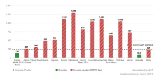
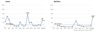
On Tuesday, September 22, the newest day of results posted to the state's sampling dashboard, 17 of 20 sites exceeded the standard of 235 colony-forming units per 100 milliliters. The Highway 50 bridge near Lamar read 727 for the second day in a row. The river below the McClave drainage read 1,046, up from 114 the day before. Below John Martin Dam the reading was 649, after 1,203 on Monday, September 21. Holly read 1,553 on September 21 and 236 on September 22. Only Fountain Creek at Pueblo, Granada and the reservoir itself complied.
The reservoir has never come close to the line. Sampled at the east boat ramp almost daily since September 11, it has read between 1 and 53, with 50 on September 22.
©
Rain, and a canal around the reservoir
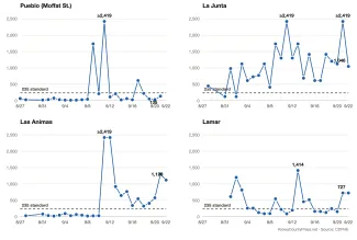
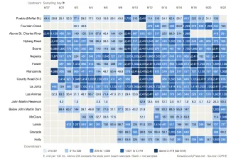
The pattern of the past two weeks is rain followed by a jump in readings. NOAA's record for Pueblo's airport shows rain on Wednesday, September 16, and the next day readings spiked at Pueblo, Fountain Creek and above the St. Charles River, where the sample came back at 1,986. Rain fell again on Sunday, September 20, and Monday, September 21. The federal river gauge at Las Animas rose from 32 cubic feet per second on September 20 to 124 on September 22, and the readings at Boone, Nepesta, County Road 24.5 and La Junta all went to the top of the lab's scale, above 2,419, on September 21. Runoff carries bacteria from streets, fields and ditches into a river, so readings climb after a storm and fall as the pulse passes, as they did after the rain of September 8.
©
The lower river has not been the clean end of the system since the first runoff pulse reached it. Lamar read 1,414 on Sunday, September 13, and Granada 1,203 on September 15, and Holly has exceeded the standard on five of the last seven sampling days. But the river directly below the dam had complied on every one of its 17 samples until September 21, when it read 1,203. In a fact sheet linked from its spill page, the Colorado Department of Public Health and Environment says the contaminated water "has now traveled downstream beyond John Martin Reservoir due to a canal bypassing the reservoir." The state does not name the canal. The Fort Lyon Canal, which takes water from the river above the reservoir and carries it past the dam, read 816 at County Road RR on September 22, and the Catlin Canal headgate read 1,203.
©
The department's advisory has not changed. It still tells people to stay out of the river from where Fountain Creek enters it through John Martin Reservoir, and it has not extended that advisory below the dam, where the readings are now as high as those above it. CDPHE has issued no news release on the spill since September 4, when it lifted the advisory for the reservoir.
Who is sampling, and how the state labels it
Since Saturday, September 12, most of the river samples have been collected by a third-party contractor, according to the state's data, which lists the sampling organization for each result. CDPHE staff still sample the sites below the dam and at McClave, and the City of Pueblo's wastewater department samples the Catlin Canal headgate. Before September 12 the state listed its own staff as the sampler at every site.

© iStock - posonsky - 1310166610
The state has also changed how it labels results. Through mid-September the dashboard called each sample "safe" or "not safe for recreation." Every result, including the older ones, is now labeled as complying with or exceeding the swim beach standard. The fact sheet explains the standard: under state water quality rules, a single sample above 235 requires a swim beach to close, and the department says that number, and not the 126 limit that applies to some kinds of irrigation, is the one it uses for the river. The department also says it has no river standard for E. coli that protects agricultural use, and it points growers to the Colorado Department of Agriculture for guidance.
Beyond bacteria, the state has tested the river for metals, nutrients and dissolved minerals at sites from Pueblo to Holly and posted those results as a spreadsheet, with samples through September 8.
How the spill happened, in the city's words
The City of Pueblo posted a fuller account of the spill on September 14. The leak was found when the treatment plant's average flow for August 26 came in 3 million gallons below what it should have been, Wastewater Director Andra Ahrens said. Once the cause was identified, it took two hours to divert the flow and stop the release.
The city's sewer runs inside its storm sewer along that stretch: a 48-inch sanitary pipe inside a 102-inch brick storm pipe, from Santa Fe Avenue to Confluence Park, where the two separate. The sanitary pipe had been put under pressure to bypass a 60-inch pipe that was being rehabilitated, and the pressure broke a patch on the sanitary pipe. Sewage flowed into the storm pipe and out its channel into the river. The state's fact sheet describes it as a contractor repairing sewage pipes who inadvertently broke a main line. The state has put the volume at about 4.25 million gallons.
What still applies
The department's guidance for the river from Fountain Creek through John Martin Reservoir remains in place: do not swim, wade, tube, kayak or fish; keep children, pets and livestock out of the water; do not drink untreated river water or use it on fruits or vegetables eaten raw. Anyone who gets in the water should wash with soap and clean water and see a doctor if diarrhea, vomiting, cramps or fever follow.
© KiowaCountyPress.net
Readers below the dam are left to judge for themselves. The state's own numbers now show Lamar, McClave and the river below the dam above the swim beach standard, while the advisory stops at the reservoir.
The Press has covered the spill since it reached John Martin, including the first two weeks of readings, the runoff surge of September 9, and the record-low year of river below the dam that has left so little water to dilute it. Results are posted on CDPHE's spill page. The September 22 samples were the newest posted as of Friday, September 25.